Wednesday, December 28, 2022

Returning to the Ernestina

December 28, 2022 EDIT 

Greetings from State Pier in New Bedford, where my son Harvey took this
nice photo on December 27, 2023 -- a couple weeks after the
Schooner Ernestina-Morrissey returned to its permanent home.

When I posted this photo on Facebook and Instagram, I promised to post comments with some details related to this boat and my teaching. I then realized I had a lot to say, so the comments will point to this post (which will probably evolve in coming days).

In the original post, I mentioned undergraduate research I have been mentoring and two courses I will be teaching in 2023. None of these will be on board the Ernestina, but all of them relate to the ship's incredible legacy that connects New Bedford to the wider world. 

This post will be edited as I have time to add some of those connections. For now, the three teaching connections I mentioned originally: 

First, I had the great privilege of mentoring a Bridgewater State University who has completed a fascinating museum exhibit on the connections between Cape Verde and Cape Cod. The project was funded by WHOI Sea Grant and is described by my colleague Brian Benson in the article Cape Connection. Carolyn King's research for this project is complete, and the installation is currently is progress. I will be posting details for in-person and virtual access in coming weeks.

Second is Coffee & Volcanoes: Travel Course in Cabo Verde. The course will take place in Cabo Verde in May 2023. Application deadline is February 24, 2023. This is available for undergraduate credit, graduate credit, or non-credit participation. The credits easily transfer to other universities.

Third is my domestic travel course GEOG 296/520 New Bedford: Maritime City, which I will offer July 17-28, 2023. I originally offered this as New Bedford Fortnight but eventually concluded that not enough people know that "fortnight" simply means "two weeks," which is the duration of the course. I named it in contrast with an earlier summer course, Coffee Week. I have offered the New Bedford Course a few times, but have never gotten enough students to allow it to run. We came close in 2022, so I am trying again. I have not posted details yet but my course blog gives a pretty good sense of what we will be doing for those two weeks of three-hour classes.

I will add a few more things here about the ship itself -- meanwhile, please visit the Ernestina web site.

Wednesday, December 07, 2022

Bittle Groun'

The title of this post -- Bittle Groun' -- means (more or less) "food land" in the Gullah Geechee language. I claim no competence in the language, but I am thankful for the Gullah Words glossary for allowing me at least to recognize the language. It is hosted on the Gullah Tours web site and draws on the work of Ambrose E. Gonzales and Alphonso Brown.


The St. Helena Island restaurant shown above is far more than a restaurant. It is the hub of one of several communities along the South Carolina coast that Padma Lashki visits in the Gullah Geechee episode (s1e4) of her magnificent Taste the Nation series on Hulu. She is herself a migrant and the series focuses on communities in which the foodways of communities (either migrant or indigenous) contribute to a local sense of place. 

Here is a trailer for the episode in which she explores the Gullah Geechee nation through the foods grown, cooked, and taught by the descendants of people brought in bondage to this area from the Rice Coast of West Africa, specifically because of their expertise in cultivating rice in coastal lowlands.
The first person she interviews, for example, is  writer Michael W. Twitty, a food scholar who identifies as an Africulinarian and knows that his family was taken from what is now Sierra Leone. Tragically, they were marginalized and abused by people who relied on both their labor and their expertise to build fortunes in plantation agriculture.
Gullah Geechee homes on Sapelo Island.
Photo: Richard Burkhart via CSM

Whether or not you are able to access the show through Hulu, I recommend several recent articles about Gullah Geechee in particular and the restoration of African American connections to land in general (in addition to the links sprinkled throughout this post). 

The first of these was recommended by my favorite librarian. "In Georgia’s Hogg Hummock, a fight for a people, a culture, and the land" was recently published on Christian Science Monitor.  For a broader discussion, see "Foraging, Farming, Hunting, and Storytelling: How Black Creators Are Growing Emancipated Spaces" posted to kitchnn by Kayla Stewart in recognition of Juneteenth this year. Steward mentions the tremendous work of Alexis Nicole, who brings humor and brilliance to this topic on TED Radio Hour, her Black Forager channel, and many other venues.

NOTE: This post is the basis for a lesson in my environmental geography course. A federal judge recently issued a ruling protecting this kind of teaching from government interference. The governor of Florida had recently attempted to block all teaching of this kind in his state's universities.  I am lucky to live in a state that would not elect such a person as governor; more importantly, though, I live in a country with a First Amendment. Even in Massachusetts we have ongoing threats to academic freedom, but not of this ideological sort.

Lagniappe

I am overdue for a return to the Charleston area, which I visited in 1990, 2000, and 2010. Each visit was for a different purpose, but each time included a visit with friends we had made in Puebla, Mexico in 1989. We had no such agenda in 2020 (and would probably have canceled it anyway), and did not become aware of Gullah Geechee culture until very recently. So I hope to return to the area soon to revisit those friends while we are all still young -- this time spending some time with Gullah Tours, Gullah Grub, and the rest of the Gullah Geechee Heritage Corridor. 

Monday, November 21, 2022

21e

WORKING DRAFT

Although I my employment has been primarily academic for most of the past 35 years, I did have two extended brushes with professional employment outside of the so-called Ivory Tower (where I have encountered very little ivory and very few towers, by the way). The second of these -- at the end of my doctoral program -- was in various roles at The Wornick Company, which was then (and probably still is) the largest purveyor of combat and humanitarian rations. 

I learned quite a lot at Wornick that I still use in my teaching, but I learned even more at Dames & Moore, where I worked just prior to starting my doctoral courses. It was a civil engineering firm with offices worldwide, which had recently (I believe) started to develop expertise in environmental regulatory compliance. I worked in Cincinnati, as part of a team of about 10 "regulatory analysts" within an office of about 80 employees. We were mostly geographers, with the rest of the group mostly engineers and a few geologists, graphic artists, and clerical staff. 

I remember my first day on that job; I started on a day when several of the people I would normally work with were gone. So I was left -- almost like a substitute teacher -- with some simple tasks so that I could be at least somewhat productive. Proctor & Gamble had recently bought Fisher Nuts, and I was to make some phone calls about a particular packaging facility in Kentucky. 

That kind of investigation for property transfer became a large part of my work during what turned out to be year full of learning experiences. I also worked on applications for permit applications -- I remember power-line routing, sediment remediation, and hazardous-waste treatment -- but most of my work was what we called Phase I Site Assessments. Whenever a client (or a client's client) was buying a company,  we would be given addresses of specific properties that were included; in some cases -- as with Fisher Nut -- this would mean several of us dividing a list and spreading out to different jurisdictions. In most cases, though, we just had 1-3 addresses in the same area and a very short turn-around to conduct that Phase I.

As soon as I got such an assignment, I would immediately schedule a visit, buy plane tickets, and book a rental car and hotel. I would do the client a favor of doing the visit on a Friday or Monday if possible, so that I could include a Saturday-night stay. Back then, the economics of flying was such that a short-notice reservation was much shorter if it included weekend travel -- so much cheaper that this would more than pay for my extra day. As a geographer and insatiable explorer, I almost always did this -- and still have fond memories of exploring on my own. In Charleston, this meant dinner with a friend I had met in Mexico and in Texas it meant knowing my way around the Rio Grande Valley before we ended up moving there a few years later. In fact, because these trips usually involved a visit to local libraries, I had actually been in the reference department of a library where my spouse would later become head of reference. 

The visits were always scheduled quickly, because our work would take place only after a sale (or a loan or an insurance policy) was imminent. We also had to be very careful about asking questions, because in many cases we had news of a sale that could be considered insider trading -- and none of us expected to be treated as well as Martha Stewart if we went to jail. (I mention Fisher Nut freely, because this was over 30 years ago. 

I would then prepare FOIA requests for every public agency that might have information about the property or its neighbors. This was part of helping the client -- who was usually a buyer  due diligence, 

https://maps.massgis.digital.mass.gov/MassMapper/MassMapper.html 

https://www.mass.gov/info-details/massgis-data-massdep-tier-classified-oil-andor-hazardous-material-sites-mgl-c-21e#overview- 

https://www.mass.gov/service-details/re77c13-21e-for-commercial-real-estate 


Lagniappe

Insomniacs might enjoy scrolling through my Fun Jobs List, where I list all of my jobs, including those mentioned above and many others of a more fleeting and often less rewarding nature. 

Saturday, November 19, 2022

Fashionable Reckoning

Just as the first book I purchased on Amazon the online store was about Amazon the forest, the most recent video I purchased on the site is about Amazon the river. Specifically, it is the second episode of the first season of Rivers of Life, recommended by a fellow geographer and available on PBS and Amazon Prime.

But this post is not about the Amazon -- it is about the Nile, because my favorite librarian and I decided to watch the series in order, and it begins with what is commonly thought of as the longest river, followed by the other top contenders: the Amazon and the Mississippi. It so happens that we watched the Nile episode on the same day that our EarthView team had been showing our giant floor map of Africa to some delightful second graders. I had been spending quite a bit of the morning looking at the Nile and its tributaries -- especially when the last group decided that they would ALL use their feet to measure the river!

This geographer on our Africa map, sans second graders.

While looking at the big print map, I remember looking at various headwaters areas, and noticed for the first time that one of the tributaries near Lake Albert is called the Albert Nile. I learned a lot of geographic details from the PBS program that I wish I had known to share with the kids, and that I hope I remember next time! Two of these are that the Nile stretches from the equator to more than 30°N and that Lake Victoria is the world's largest tropical lake. The program and I both point out that the Nile -- like virtually all rivers -- has more than one source. 


I recommend watching the show as I did -- with a laptop handy, open to Google Maps. I will be doing this for all of the remaining episodes. Among the most interesting things I learned this way is that some of the river's major tributaries pass through areas that are either so narrow (rocky gorges) or so broad (marshy wetlands) that they really do not appear as rivers on satellite imagery. 

All of this was in mind -- especially some questions I had about Lake Albert and the Albert Nile -- when I heard a story about a project of post-colonial reckoning at a London museum. More specifically, the Victoria and Albert Museum -- named for two leaders in the colonial subjugation of the continent -- has launched an exhibit that highlights post-colonial African fashions. As the museum web site describes the exhibit, "Africa Fashion explores the vitality and global impact of a fashion scene as dynamic and varied as the continent itself."

At right, from the exhibit: 

Alchemy collection, Thebe Magugu, Autumn/Winter 2021, Johannesburg, South Africa. Photography: Tatenda Chidora , Styling + Set: Chloe Andrea Welgemoed, Model: Sio

On the western side of the continent, by the way, I told a couple of stories about the brilliant and fabulous singer Angélique Kidjo. I showed them her home country of Benin and described her anthem Afrika (which I heard her perform in Providence in early 2020) and the ballad Iemanja, which was my introduction to her beautiful and multilingual body of work. 

Lagniappe

African leaders on our Africa map: the Bridgewater State University 2022 class of the Mandela Washington Fellowship program.

Context: Following the death of Nelson Mandela, the Young African Leaders (YALI) Fellowship program was renamed in his honor. Each year, 40 colleges and universities around the United States host 25 Fellows each for a six-week program of professional development, followed by a two-week program with all 1,000 Fellows in Washington, DC. BSU has hosted Fellows for each of the past several years, and they have always had a visit with our EarthView program -- going inside the globe and exploring the National Geographic floor map. In this 2022 visit, one of the participants suggested sitting around the edges of the continent rather than each standing on their own country -- a much better visual! 

Monday, November 14, 2022

Crossing the Bay


I took this photo yesterday (November 13, 2022) -- at the beginning of my second walk across the southern span of the twin-span Chesapeake Bay Bridge. The first walk had been with my favorite librarian and eventual spouse, so long ago that we did not even know she was going to be a librarian yet. She was with me this time as well, along with our sister-in-law, who now lives at the far end of this bridge. This year my brother shuttled us to the shuttle, but we will all four do this together some time! 

The bridges were built in the 1960s where a ferry had previously operated. The first span has two lanes and was augmented with the three-lane span some years later, but long before I moved to the area in 1980. Neither span has even the hint of a sidewalk or bike lane, so the occasional opening for a walk is a real treat.

When we walked in 1986, it was not yet a regular event. It is now known at the Chesapeake Bay Bridge Run/Walk, a 10k event that is popular among those who travel to such things. 


Wh

NOTE: If this is the last paragraph you see in this post, please come back later. I don't know how many geographers were among the 16,000 people in this crowd, but there was one at least, and he has some geographic observations (and more maps) to share!

Wednesday, November 09, 2022

Towering Emergent

A friend who is both a geographer and a librarian (great combination!) recently shared the story of a very tall tree. Indeed, this beautiful 290-foot angelim vermelho is the tallest tree ever measured in the Amazon rain forest. 

Image: Imazon/Idelflor/AFP

An October article in Nature tells the story of this tree, which emerges so high above the surrounding canopy that the individual tree was identified by remote sensing. Its distance from roads and rivers made it very difficult to reach and this indeed is what has allowed it to grow to this size. Even knowing exactly where it was, researchers spent a lot of time and effort to reach it. 

And to protect it, the location is described only vaguely in the article; they indicate only that it is somewhere in the reserve shown below, well to the west of Belem. Wood poachers sometimes destroy large tracts of forest on their way to harvesting a single specimen like this.

The article does not use the term "emergent" but that is what such towering trees are called. They require an enormous base of buttresses for support, because roots reach only a few inches into the surprisingly poor rainforest soils.

The Environmental Geographer showing off the 
buttresses of a much smaller tree in a different
part of the Amazon in 2003.

The article mentions not only the hardships of the journey to the single tree in Amapá, but also a large number of people involved in the work. I remember a presentation by a scientist who mounted a similar expedition to find rare lemurs in Madagascar. She and a photographer and a guide were going, but they needed people to cook food, carry the cameras, and carry the tents. And then those people needed more tents, food, and the like. In this way an expedition of 2-3 people quickly becomes almost two dozen.


Sunday, October 30, 2022

Paving Paradise

During my first or second visit to Brazil -- it would have been 1996 or 2000 -- I remember starting a little debate among a small group of students and faculty in Porto Velho by asking a simple (it seemed) question: "Can a person drive from here to Manaus?" which is about 600 miles to the northeast. 

Half of the people present said yes, because you could take BR-319. The other said it was impossible, because that highway exists "only on the map." Both answers were correct in their own way. Two decades later, Google Maps is not ambivalent at all: get started before breakfast and you could be there by bedtime.

Just take the highway: Google Maps

The reason for the debate, of course, is that roads paved in the Amazon do not remain paved for long. Often carved into an undulating terrain with almost no surveying ahead of construction, steep slopes, poorly structured clayey soils and extremely heavy rainfall make pavement little better than gauze over time.

This all came to mind today, as I listened to a report on the paving of this very road by John Otis on NPR. The condition of this road is of international interest as the presidency of Brazil is being decided in a run-off election today. As Otis suggests in his reporting, while the previous incumbent -- the once-and-future Luiz Inácio "Lula" da Silva -- has equivocated on the question, while the current incumbent -- Jair Bolsonaro -- is firmly committed to the repaving of BR-319. 

Where there are roads, there are cattle. Deforestation is directly proportional to road construction.
The web version of the reporting by John Otis includes several stunning photos by Bruno Kelly.

As with other aspects of national policy regarding the Amazon rain forest, the choice is between ineffective protection and very effective exploitation. Within an hour of my posting this story, we expect to which direction the voters of Brazil are taking. And within an hour or two of that, we will know whether the voters will be heeded, as Bolsonaro is hinting that he might ignore the results, as his friend to the north attempted on January 6, 2021.

Update: On November 5, NPR journalist Carrie Kahn detailed the outcome of the election I had been awaiting when writing the above. It took a few days, but Lula won and the incumbent eventually stopped contesting the win. Kahn's reporting describes that win and the importance of the Amazon among Lula's challenges. UPDATE: On November 16, Kahn reported on Lula's stunning appearance at the climate conference in Egypt, which he attended instead of the sitting president.

The last academic conference I attended before the Covid lockdown was in Porto Velho, where I was invited to speak on the acceleration of deforestation there. The conferees were interested in hearing my insider/outsider views. My talk was called Fogo, Política, Bife, y Soja -- Fire, Politics, Beef, and Soy -- because they are all connected.

Lagniappes

The story mentions Dr. Philip Fearnside, the first person I met in Brazil and still one of the forest's most ardent academic advocates.

About a week after posting this story, a geographer/librarian friend shared another story from the Amazon -- this an encouraging story of discovery in an area far from any roads, in the easternmost part of the rainforest. I introduced the story in Towering Emergent.

And finally -- I am going to make that trip between Manaus and Porto Velho in 2023, but I will not see the BR-219. I will be on a boat like this, as I originally intended to do in 1996. 

The photo is by the amazing Ocampo Fernandes, posted in the online group Rondônia, Minha Querida Rondônia.


Wednesday, October 19, 2022

Nowhere-ing a Bridge

Most of the Amazon Basin is flat, very flat. How flat? Flat enough that the Rio Solimões and Rio Negro flow languidly beside each other for about 30 miles past their confluence, in the famous Wedding of the Waters near Manaus.

The slope of Amazonian rivers is remarkably flat even hundreds of miles upstream, closer to headwaters areas, as I was reminded when trying to understand this pair of photographs, which I noticed this morning on the Rondônia, Minha Querida Rondônia page on Facebook. 


Group administrator Dacosta Dacosta shared these, with the caption "Ponte EFMM de Mutum Paraná, em duas épocas" (Madeira-Mamoré Railroad bridge at Mutum Paranà, in two different periods).

My first instinct was to look for the bridge on Google maps, based on the place name he used. There is an interesting difference between the map version and the satellite version of the map right now; the map has not caught up with this inundation, even though it seems to be more or less permanent.
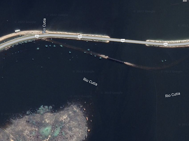

Both images, Google Maps as accessed October 19, 2022

The main indication that this is a permanent flood -- indeed, an anticipated flood -- is that a causeway and  bridge were built for the BR-364 highway, where nothing more than a culvert is present on the map version.

 I assumed that this related to hydroelectric projects that were completed about a decade ago -- none were present during my first three visits to the area, but I did see the Santo Antâo dam when I returned in 2019. My master's thesis involved finding dams of various sizes on aerial photographs and satellite images, so I assumed searching the area of the lake that now contains Rio Cutia would be simple. I looked over this area, to no avail:

Back I went to Google. This time I searched for the Mutum Paraná and the word "usina" for hydroelectric plant. I remember the word from visiting and researching Usina Samuel on the Rio Candeias years ago. This led to an article about Usina Hidrelétrica de Jirau, which fortunately includes geographic coordinates --  9°15′51.8″ S, 64°38′30.8″ O. Realizing that O is for Oeste, I searched for this lat/long, changing the last character to W, and found the Jirau hydroelectric. 
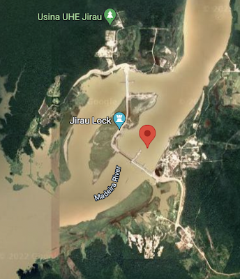
Usina Jirau, Google Maps accessed on
October 19, 2022

Zooming out, I could see that this is nowhere near the inundation that first got my attention. In fact, it is about 60 kilometers (35 miles) downstream -- with many miles in between where the Madeira (the Amazon's longest tributary) seems to be within its normal banks.

The engineers who built the dam, however, know exactly how flat this land is, and they used Geographic Information Systems to figure out where the floods would be and what steps they would need to take in order to protect the BR364 highway as it passes over what was previously a trivial tributary, many miles from their main project.

Lagniappe

During my first visit to Rondônia (Brazil's 26th state) in 1996, I saw the first internet server while it was still in a shipping box. For years after, my (now outdated) Rondônia Web page was the only online English-language resource about the place. Now it is a place full of very connected people of all ages, and this particular Facebook group has almost as many members as the entire state did in 1960. This page is similar to many groups pages I find in U.S. communities, brimming with nostalgia.


Monday, October 10, 2022

The "Crying Indian" Ad

 Anybody who was watching U.S. television in 1970 and the following few years will remember the poignancy of this video, which was called Keep America Beautiful but was better known as the Crying Indian. It was released around the time of the first Earth Day. 

I do remember learning much later that the actor was not Native American: he was Italian-American Iron Eyes Cody (1904-1999). Still, I thought, the video was well-intended, and it did cause people -- at least some people -- to think about our place in the environment. 

It was not until I started looking for the video for this year's Indigenous Peoples Day that I learned the insidious background of the story. Writing for the Chicago Tribune in 2017, journalist Finis Dunaway argues that the ad fooled the environmental movement by shifting attention -- and thereby responsibility for pollution away from manufacturers and toward individuals. It was, Dunaway argues, part of a greenwashing campaign that ushered in an era of disposable packaging. Half a century later, we still struggle to develop sustainable waste-management strategies that actually existed prior to this ad.   

Writing for The Columbian (Vancouver, WA) in April of this year, journalist Greg Jayne offers a different perspective, insisting that the ad had a positive influence on a generation of young people.

Blog Ideas

coffee (25) GEOG381 (24) GEOG388 (23) GEOG470 (18) climate change (18) GEOG130 (16) geography (16) GEOG332 (13) GEOG431 (12) musica (11) GEOG 332 (9) GEOG 381 (9) Mexico (9) Brazil (8) GEOG286 (8) Texas (8) education (8) migration (8) GEOG298 (7) borderlands (7) GEOG199 (6) GEOG331 (6) Massachusetts (6) US-Mexico (6) deBlij04 (6) immigration (6) GEOG 130 (5) GEOG 286 (5) GEOG287 (5) climate justice (5) cultural geography (5) fair trade (5) food (5) geographic education (5) nicaragua (5) water (5) Arizona (4) GEOG 171 (4) GEOG171 (4) GEOG295 (4) Safina (4) africa (4) deBlij05 (4) land protection (4) music (4) politics (4) Bolivia (3) Boston (3) COVID-19 (3) Detroit (3) Ethiopia (3) Managua (3) Obama (3) border (3) cartography (3) drought (3) libraries (3) pesticides (3) suburban sprawl (3) trade (3) unemployment (3) Alaska (2) Amazon (2) Bridgewater (2) Canada (2) Chiapas (2) China (2) Colonialism (2) EPA (2) EarthView (2) Economy (2) Environment (2) GEOG 199 (2) GEOG 287 (2) GEOG 388 (2) Google Maps (2) Government (2) Hawaii (2) India (2) Lexington (2) Maldives (2) Mozambique (2) NOLA (2) NPR (2) National Monuments (2) National Parks (2) New Orleans (2) Religion (2) Rio Grande (2) Taunton River Wild and Scenic (2) Tex-Mex (2) The View from Lazy Point (2) United States (2) Venezuela (2) anthropocene (2) cape verde (2) censorship (2) central america (2) chocolate (2) corn (2) deBlij07 (2) deforestation (2) demographic transition (2) demography (2) education reform (2) employment (2) environmental geography (2) film (2) forest fire (2) global warming (2) islands (2) landscape ecology (2) librarians (2) maps (2) organic (2) peak oil (2) refugees (2) sense of place (2) soccer (2) sustainability (2) television (2) water rights (2) whales (2) #bbc (1) #nicaragua (1) #sosnicaragua (1) #sosnicaragua #nicaragua (1) 100 Years of Solitude (1) ACROSS Lexington (1) Accents (1) Adam at Home (1) Alice (1) Alt.Latina (1) American Hustle (1) April (1) Association of american Geographers (1) Audubon (1) Aunt Hatch's Lane (1) BBC (1) BSU (1) Baby Boomers (1) Banda Aceh (1) Bay Circuit Trial (1) Bechtel (1) Beleza Tropical (1) Belize (1) Beloit College (1) Ben Linder Cafe (1) Bet The Farm (1) Bhopal (1) Biafra (1) Bikeway (1) Bikini (1) Bill Gates (1) Bill Moyers (1) Boeing 777 (1) Brazilian (1) Brazilianization (1) Bridge (1) British Columbia (1) Brockton (1) Bus Fare (1) Bush (1) Cabo Verde (1) California (1) Cambridge (1) Cape Cod Bay (1) Carl Stafina (1) Catholic (1) Ceuta (1) Chalice (1) Chipko (1) Citgo (1) Climate risks (1) Cochabamba (1) Colombia (1) Common Core (1) Commuter (1) Computers (1) Cuba (1) Cups and Summits (1) Dallas (1) David Byrne (1) Deans Beans (1) Delaware Valley (1) Dunkin Donuts (1) Earth Day (1) Earth View (1) Easton (1) El Salvador (1) Elizabeth Warren (1) Ellicott City (1) Emilia Laime (1) English-only (1) Environmental History (1) Euphrates (1) European Union (1) Evo Morales (1) FIFA (1) FYS (1) Fades Out (1) Farms (1) First-Year Seminar (1) Food Trade (1) Frederick Kaufman (1) French press (1) Fresh Pond Mall (1) GEOG 431 (1) GEOG 441 (1) GEOG213 (1) GEOG490 (1) Gabriel García Márquez (1) Garden of Gethsemane (1) Gas wells (1) Gateway Cities (1) General Motors (1) Gini Coefficient (1) Girl in the Cafe (1) Google (1) Gordon Hempton (1) Gravina Island Bridge (1) Great Migration (1) Great Molasses Flood (1) Guy Lombardo (1) Haiti (1) Hawks (1) Heart (1) Higher Education (1) History (1) Holyhok Lewisville (1) Homogenous (1) Honors (1) How Food Stopped Being Food (1) Hugo Chavez (1) IMF (1) Iditarod (1) Imperial Valley (1) Income Inequality (1) Indonesia (1) Iraq (1) Irish (1) Japan (1) Junot Diaz (1) Kenya (1) Ketchikan (1) Key West (1) Kindergarden Students (1) King Corn (1) Kiribati (1) Latin America (1) Limbaugh (1) Literature (1) Living On Earth (1) Louisiana (1) Love Canal (1) Luddite (1) M*A*S*H (1) MCAS (1) MacArthur Genius (1) Maersk (1) Malawi (1) Malaysia (1) Malaysian Air Flight 370 (1) Mali (1) Manu Chao (1) Map (1) Marblehead (1) Mary Robinson Foundation (1) Maryland (1) Massachusetts Bay Colony (1) Math (1) Maxguide (1) May (1) Maya (1) Mayan (1) Mayan Gold (1) Mbala (1) McDonald's (1) Melilla (1) Mexicans (1) Michael Pollan (1) Michelle Obama (1) Micronesia (1) Military (1) Military Dictatorship (1) Minuteman Trail (1) Mongolia (1) Monsanto (1) Montana (1) Morocco (1) Mount Auburn Cemetery (1) Muslim (1) NPS (1) Nantucket (1) National Education Regime (1) Native American (1) Native Americans (1) New Bedford (1) New Hampshire (1) New York City (1) New York Times (1) Nigeria (1) No Child Left Behind Act (1) Norquist (1) North Africa (1) Nuts (1) Oakland (1) Oaxaca (1) Occupeligo (1) Occypy (1) Oklahoma (1) Oklahoma City (1) Oppression (1) PARCC (1) Pakistan (1) Pascal's Wager (1) Peanut (1) Pearson Regime (1) Philadelphia (1) Philippines (1) Pink Unicorns (1) Poland (1) Portuguese (1) Protest (1) Public Education (1) Puebla (1) Puritans (1) Quest University (1) Rachel Carson (1) Reading (1) Republican (1) Retro Report (1) Robert Reich (1) Rock Legend (1) Ronald Reagan (1) Rondonia (1) Rosa Parks (1) SEXCoffee (1) Safety (1) Samoza (1) Sandino (1) Sara Vowell (1) Save the Children (1) Scotch (1) Scotland (1) Seinfeld (1) Senegal (1) Sergio Mendes (1) Severin (1) Sharrod (1) Silent Spring (1) Sinatra (1) Slope (1) Smokey the Bear (1) Somalia (1) Sombra (1) Sonora (1) Sonoran desert (1) Sonoran hot dog (1) South America (1) Spain (1) Stairway to Heaven (1) Storm (1) Suare Inch of Silence (1) Sumatra (1) Swamp (1) Tacloban (1) Tanzania (1) The Amazon (1) The Amazon Trail (1) Tigris (1) Tucson (1) Tufts (1) U.S Federal Reserve (1) U.S Government (1) U.S. economy (1) USDA (1) USLE Formula (1) Uganda (1) Unfamiliar Fishes (1) Union Carbide (1) Vacation (1) Vexillology (1) Vietnam (1) ViralNova (1) WNYC Data News (1) Wall Street (1) Walsenburg (1) Walt Disney (1) Walt and El Grupo (1) Ward's Berry Farm (1) West (1) Whaling (1) Wilson (1) Winter Storm Saturn (1) Wisconsin (1) World Bank (1) Xingu (1) YouTube (1) Zombies (1) agriculture (1) antitrust (1) aspen (1) austerity (1) aviation (1) banned books (1) bark beetle (1) bean (1) beavers (1) bicycle (1) bicycling (1) bike sharing (1) binary (1) biodiversity (1) bioneers (1) books (1) boston globe (1) cacao (1) cafe (1) campaign (1) campus (1) cantonville (1) capitals (1) carbon dioxide (1) carbon offsets (1) carioca (1) cash (1) cashews (1) census (1) chemex (1) chemistry (1) chronology (1) churrasco (1) civil rights (1) coffee grounds (1) coffee hell (1) coffee prices (1) coffee quality (1) college (1) compost (1) computerized test (1) congress (1) conservation commission (1) corporations (1) countries (1) cubicle (1) dams (1) deBlij06 (1) deBlij08 (1) death (1) deficit (1) development (1) dictatorship (1) distracted learning (1) distraction (1) drug war (1) dtm (1) earth (1) economic diversification (1) economic geography (1) election (1) embargo (1) energy (1) enhanced greenhouse effect (1) environmentalist (1) ethnomusicology (1) exremism (1) failed states (1) farming (1) financial crisis (1) football (1) forestry (1) forro (1) fracking (1) free market (1) free trade (1) fuel economy (1) garden (1) genocide (1) geography education (1) geography games (1) geography of chocolate (1) geography of food (1) geologic time (1) geotechnology (1) gerrymandering (1) global pizza (1) globe (1) goodall (1) green chemistry (1) ground water (1) guacamole (1) guatemala (1) habitat (1) high-frutcose (1) home values (1) hospitality (1) hourglass (1) housing (1) hydrology (1) illegal aliens (1) income (1) indigenous (1) interfaith (1) journalism (1) kitchen garden (1) labor (1) language (1) libertarianism (1) library (1) linguistics (1) little rock (1) llorona; musica (1) macc (1) maccweb (1) magic realism (1) maple syrup (1) mapping (1) masa no mas (1) massland (1) medical (1) mental maps (1) mi nina (1) microlots (1) microstates (1) mining (1) mltc (1) monopoly (1) municipal government (1) nautical (1) neoclassical economics (1) new england (1) newseum (1) newspapers (1) noise pollution (1) pandas (1) petroleum (1) piracy (1) pirates (1) poison ivy (1) police (1) political geography (1) pollution (1) provincial government (1) proxy variables (1) public diplomacy (1) quesadilla (1) rabbi (1) racism (1) real food cafe (1) regulations (1) remittances (1) resilience (1) resistance (1) respect (1) rigoberta menchu (1) rios montt (1) romance (1) roya (1) runways (1) russia (1) satellites (1) science (1) sea level (1) selva negra (1) sertao (1) sertão (1) sex (1) sex and coffee (1) simple (1) sin (1) smokey (1) solar (1) solar roasting (1) south africa (1) sovereignty (1) species loss (1) sporcle (1) sports (1) state government (1) taxes (1) tea party (1) teaching (1) textile (1) texting (1) tortilla (1) training (1) transect; Mercator (1) travel (1) triple-deckers (1) tsunami (1) urban geography (1) utopia (1) vermont (1) vice (1) video (1) wall (1) water resources (1) water vapor (1) whiskey (1) whisky (1) widget (1) wifi (1) wild fire (1) wildfire (1) wildlife corridor (1) wto (1)