Wednesday, November 27, 2013

Two Things We Are Against

Former Maryland Governor Parris Glendening has often quipped that there are two things we are against when it comes to land use: sprawl and density.
The realty industry's latest survey of community preferences bears this out, as described in an Atlantic article whose title is blunt: Americans Are Very Confused About What They Want Out of a Community. It is no coincidence that a generation essentially devoid of geographic literacy is also confused about the conflicting desires for the organization of local space.

This confusion creates a feedback loop, as people arrive in suburbs and then almost immediately start demanding changes to meet expectations that are not appropriate for low-density settlements.

Saturday, November 16, 2013

Internal Borders

As many readers of this space know, my favorite librarian and I spent three years in the mid-1990s living in Pharr, Texas, about as close as one can live to the U.S. border with Mexico. The town is in the center of the Rio Grande Valley, a term that could refer to much of Texas, New Mexico, and Old Mexico, but which really refers to the delta area of the river that forms much of the boundary between our two countries. The Valley itself is a bit of both lands, and living there was really a privilege and an important part of my education as a geographer.

A couple of hours ago I was pleasantly surprised to hear the Valley town of Raymondville mentioned by someone recounting a personal story on This American Life. It is rare to hear a story from the Valley on National Public Radio, and even more rare to hear it in the first person. Compounding my surprise was the proper use of the term Whataburger -- a Valley institution frequently used in giving directions (as DD is here in the Bay State).

As fans of the program know -- and we are definitely fans in Casa Hayes-Boh -- each week the producers select a theme, and bring listeners stories related to that them. The theme of today's show (originally aired in October 2012) was "Getting Away With It." In this case, it is a story about the running of illicit drugs, but it is told from a point of view that is not sensational, and mostly about family dynamics that could play out anywhere.


The yellow balloons on the map below indicate places mentioned in the story -- the Raymondville balloon will guide readers directly to the Whataburger -- including one mentioned erroneously. The border patrol station on Route 281 is not in Hebronville (shown with a dotted balloon), but rather in Falfurrias.


That station is quite familiar to me, as I frequently stopped there on my weekly travels from our home in Pharr to Alice High School (both shown with blue balloons). I taught an evening course there for several semesters, in return for a small stipend and gas money (which was almost as much as the stipend), and mainly for the opportunity to continue gaining teaching experience. I taught at Alice High School, but it was actually an extension program of Texas A&M University-Kingsville. When driving to campus, I always had to stop, just as if I were entering the United States from abroad. I was annoyed, but tried not to show it. I eventually learned that a necktie and a Texas A&M parking permit on the front of the car would get me through much more quickly.

For the narrator in the story above, it is clear that although the contraband to be trafficked was already in the United States, it could not get to market without going through one of the interior "crossings" in Falfurrias or Sarita.


View Take Your Kid to Work Day in a larger map

In preparing this post, I got an interesting lesson in social media. When I asked a friend in the Valley to help me confirm the location of the Falfurrias station (which I had on the wrong stretch of road), she looked it up on the Migra's Facebook page! I would never have thought of that.

Thursday, November 14, 2013

Brockton Water Update

When I first moved to southeastern Massachusetts, I started learning about my local watershed, that of the Taunton River. I also began to learn about the critical water shortages in the nearby city of Brockton. Water shortages were a topic of modest concern in Bridgewater, but how could they be of such critical concern in a city so close by that it was once known as North Bridgewater?
This is a geographic question, of course. I was pleased to have the chance to explore the question at the 2006 annual meeting of the D.W. Field Park Association, leading me to offer an entire course on the geography of Brockton in 2007 and 2008.

In preparing to offer an honors section of that course in the Fall 2014 semester, I found an interesting article about the desalination plant in Boston magazine. Amy Crawford's Tapped Out explains how the desal plant that went from "pie-in-the-sky" to "under construction" in the period leading up to my first course now appears to be in the "albatross" category. She explains several factors that have converged to turn the ambitious project on the lower Taunton River into a very expensive backup plan.

Among these reasons are better-than-expected results from conservation efforts -- extraordinary among U.S. cities -- and the fact that neighboring towns have proved unwilling to participate, so that fixed costs are borne entirely by Brockton. Assuming the plant remains operable, a rapidly changing climate might very well change some of those calculations, but for now Brockton's only hopes lie in very dubious legal strategies.


View Larger Map

Tuesday, November 12, 2013

Climate Foxholes

This morning I was reminded of the adage that there are no atheists in foxholes. Leaving the theological implications of Pascal's Wager aside for the moment, I found a connection between two island stories this morning.

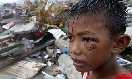
Damage in Taclovan is undeniable. Photo: Aaron Favila/AP, via The Guardian.
The first is widely known, of course, as the most powerful storm ever observed arrives in Vietnam, having pushed past numerous low-lying Pacific islands before devastating many islands of the Philippines.

The visitation of such a calamity on an island country presents special challenges, as people on some islands will have few places of  refuge. A resident of Kiribati has already sought "environmental refugee" status, and entire countries such as his are considering ways to migrate as countries to higher ground. As researcher Susan Martin points out, people who migrate always do so for multiple reasons and usually do so domestically -- the internally-displaced Dust Bowl refugees known as Oakies are a perfect example -- but anybody who is concerned with international migration must include climate-driven migration in their calculations.

When Mary Robinson addressed the Association of American Geographers in 2012 she admonished us to work diligently for climate justice, because those most vulnerable and those most responsible are not the same people, and do not live in the same places. I must admit that I thought of her remarks as referring mostly to some future condition, though the fact that daffodils were blooming in Manhattan on that February day should have been a clue. It turns out that the migration, crop loss, and impoverishment are the least of the injustices of climate change. The dying has started.


A young boy from Mr. Sano's city.
Image: Erik De Castro/Reuters via The Guardian
So it that Yeb Sano has traveled from the ruined city of Tacloban to the pointless climate talks in Poland, leaving his family behind to bring his story to the banquets halls and negotiating tables of Warsaw, hoping someone will listen to his anguish. 

The complexity of our climate means that we can each deny responsibility; climate change did not invent drought, flood, typhoon, or blizzard. But the increasing frequency of "wild weather" is now far outside the bounds set by prior experience. We predicted a new normal, and statistically, we are there. Typhoon Haiyan has been compared to a Category 5 on the hurricane scale, but this is only because Category 6 had not been contemplated when looking at the storms of previous generations. A storm sustaining winds of near-tornado strength across hundreds of miles had not been imagined before this most unusual century.

Students, parents, and educators: It is sometimes difficult to find appropriate educational materials for such an event; I recommend the Philippines storm post on Listen Edition as a possible starting point for discussion with upper-elementary and middle-school learners.

Key Considerations
Closer to home is a less dramatic story about insurance and planning in the city of Key West, Florida -- a lovely place I have not yet managed to visit. Those who manage public affairs in Key West -- and especially those who set insurance rates -- cannot afford "ivory tower" arguments about whether or not the climate is changing. In the case of those with actual responsibilities, to ignore rising seas is now unthinkable. Just as governors have shown more leadership than the national government, so too have municipal authorities and private-sector planners in Key West left debates to those who still have the luxury of entertaining denial for political purposes.

View Larger Map

Incidentally, the "comments" section of the Key West story illustrates the severity of geographic ignorance. Comments on all sides of the climate "debate" reveal profound gaps in understanding of physical systems, human settlement patterns, and math.

Lagniappe
(Posted April 15, 2014)

Image source: Climate Denial Crock of the Week
Looking for the link to my own post here, I found several other blogs that have made the same observation. Peter Sinclair, for example, focuses on reinsurers. These are pretty conservative folks as a rule, and they are not in a position to make their decisions on the basis of ideology.

Thursday, November 07, 2013

Zoom In

If you use the "PLUS" button in the upper-left of this image, you will zoom in on its center, as if decreasing your elevation above the earth. You will see one very broad change, and then something small and intriguing. You can then use the "MINUS" button to zoom back out and see the context, and just how vast this visually homogenous area is.

If you click to view the larger map, you can bring the little human figure down to the scene for an eye-level view.

You can then learn the fascinating story of how this was created from ViralNova.  Several geography and geotechnology lessons are illustrated by this exercise. One is the revelation that despite the world being a crowded place in many ways, vast tracts are essentially untouched by humans. Even in this case, however, a local community is part of the story, and it is now connected to the humanitarian and military experience of people hundreds of miles away.

The exercise also reminds us that the data about the planet that is collected by satellites is indeed vast, and that the rendering of these data into images is somewhat arbitrary. Notice the dramatic differences in color as Google Maps serves imagery (which is results from the coding of streams of digital numbers) gathered from different satellites, or from the same satellites on different days. Also notice that a current copyright date is applied to the image, no matter when the data were collected.

Wednesday, November 06, 2013

Creative Resistance


I first learned the story of the song "Calice" from the liner notes of Luaka Bop's Beleza Tropical album, the first installment in David Byrne's legendary Brazil Classics series.

The story of this song is remarkable -- bordering on incredible -- but numerous Brazilian friends have confirmed it for me. While many outspoken artists had to leave Brazil during a series of military dictatorships from 1964 to 1985, Chico Buarque de Holanda was able to stay and still publicly protest government oppression. He did so most famously with this song, which was a rallying call for millions in Brazil. On one level, it is a religious song, in which Christ prays for his Father to "take away this cup from me" in the Garden of Gethsemane. But on another level, the word "chalice" is the same as the phrase "shut up," and this song ends by mocking the military's insistence on a silenced citizenry.

Many versions of the song continue to be posted on YouTube, including a version created for a geography class that features provocative imagery from the military period  and a more recent version that features imagery from recent protests triggered by bus-fare increases.

Monday, November 04, 2013

Sergio Mendes


In this Seinfeld scene, Kramer is offended that a record reseller does not know the greatness of Sergio Mendes. It is not clear whether the writers intended for Kramer himself to be part of the joke; as important as Sergio Mendes is for bringing Brazilian music to the United States, he has not been very well known in Brazil, as he was exiled throughout almost all of the military period of 1964 to 1985, but became famous among sophisticated listeners in the U.S.

I learned of the U.S. band Black-Eyed Peas when I was walking through a book store with my mother. I noticed a display of CDs featuring their work with Mendes -- I had no idea who they were, but bought a copy without hesitation. The best known track is Más Que Nada.

The Mendes story is placed into context in the Netflix series Break It All.


Tuesday, October 29, 2013

Self Gerrymandering

As I wrote in Article One almost two years ago, the first article of the United States constitution provided for the employment of generations of geographers, by stipulating that the citizenry be counted and mapped on a regular basis. The original purpose of the Census was to ensure that Congressional representatives be selected in proportion to the population of each state and district. As everyone by now knows, geographers have been employed almost since the beginning of the Republic to reverse that process: Gerrymandering allows representatives -- to some degree, at least -- to select their voters.

In recent years, the modeling of voter geography has become sufficiently sophisticated to allow incumbents to identify and select increasingly loyal groups of voters -- people who disdain Congress in general but are incredibly devoted to their individual members of that august body. The result, as most observers realize, has been an incredible polarization of the electorate, highlighting the red and blue in a country that is essentially purple (again, see my Article One post for details.

It is in this context that political journalists Steve and Cokie Roberts encourage readers to "Turn Off the Blowhards." They cite a recent and perspicacious article by David Carr, who observes that the media -- and readers/viewers -- are increasingly gerrymandered.

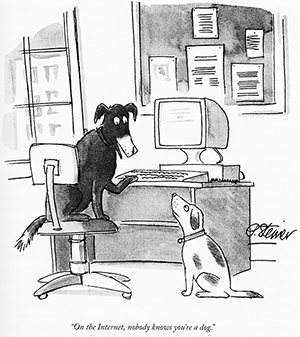
Twenty years ago, cartoonist Peter Steiner identified anonymity as one of the fundamental characteristics of the Internet. A related feature has been the incredible fragmentation of media that has been facilitated by the growth of the Web. It is increasingly easy -- and comfortable -- to become immersed in an echo chamber of those who will not challenge our assumptions, Gerrymandering ourselves into very small, very uniform districts of limited discourse. Anonymity allows forays into the intellectual turf of "others" to be limited to verbal volleys that range from snarky to abusive, but that do not resemble real discourse.

As the Robertses argue, the combination of polarized voting districts and polarized thinking districts is increased dysfunction, exemplified by ever more frequent paralysis. The reform of political districting is daunting and perhaps impossible; the reform of our own habits of mind, however, can start immediately.

Monday, October 28, 2013

Busmoor's Holiday

The term "busman's holiday" frequently comes to mind when I take any kind of a vacation, because the line between what I enjoy in my time off and what I do as a professional geographer is often blurred. It is far from a bad thing, though: if walking in the woods with with my family -- for example -- reminds me of something related to my work, I have chosen my work well, and am fortunate to have it.
My latest "Sombra" photo. I took the first first against a coffee backdrop in 2011,
when comparisons were made to the famous
"Shadow" statue of Sandino in Managua.
Twice in a fortnight, this precise example has played out. As with a walk on the Lexington rail trail two weeks ago, this morning's brief adventure in the Cape Cod moors reminded me of ongoing work I am doing with students, related to the development of the Nunckatassett portion of the Bay Circuit Trail. This weekend, the insights came as we walked through the Seabury Farm Conservation Area in Barnstable, at the recommendation of our hosts at the Lamb & Lion Inn. Equally inviting would have been the trails of an Audubon property directly behind the inn (and facing Cape Cod Bay, except that we had a canine companion with us, who is precluded by the Audubon management plan. The admissibility of dogs is an important consideration in any open-space management, and this area of Barnstable now has ample public land in both the dog and non-dog category.

When Pam and I -- and our doglet Perry -- stepped into the scene above, I exclaimed "The Moors!" as I was reminded of the upland grasslands of Sherlock Holmes and the Hound of the Baskervilles (though our min-pin is neither a hound nor very Baskervillian). On further discussion, we found that we each had different definition of "moor," all of which were substantiated by quick Google searches and -- more importantly -- by the Oxford English Dictionary. We learned that it can mean a highland open space, especially if covered with heather, a swamp, or any uncultivated land. We also learned that "moor" in the ecological sense has an etymology that is completely separate from the word "Moor" relating to people of North Africa.

In some contexts, "moor" refers specifically to areas reserved for shooting (that is, hunting), which is the case on this property we were walking in Barnstable. In Massachusetts, hunting is allowed on public lands unless specifically prohibited, subject to certain set-backs in distance from roads and buildings. As we consider the development of trails through public lands in Bridgewater, this is an important subject to understand, as it is in any place experience rapid suburban sprawl. Newcomers are sometimes surprised to see hunters close to their homes, and long-timers are sometimes surprised to find that the places where they hunted in their youth are now off-limits. In this context, the signage used above can be a vital part of managing public trails. The photo includes another essential element of trail management, which is to identify the right level of vehicular access, and to find ways to achieve it that meet the various management objectives at a site.
I noticed this house as we were about to exit the property, along what is known as Aunt Hatch's Lane. This house was clearly in place before the recent designation of the surrounding land as public open space. In many similar situations -- I do not know whether this case is one of them -- public space becomes accessible only if access is provided across private lands. In such cases, tax benefits may accrue (a major topic in my course), along with a sense of serving the public good. It is also quite often the case that the value of this kind of property actually increases, despite the potential loss of privacy, because of its proximity to protected lands. In fact, some argue -- not without justification -- that land protection is often purused specifically as a way of protecting property values. It is certainly the case that many Massachusetts towns with a high proportion of public land also have extraordinarily high property values.

I named the photo above "buffer" because the value of the property is further enhanced by a thick growth of vegetation on a steep slope, separating it both visually and physically from the public way.

Aside from good exercise, a major reason to spend time in the out-of-doors is to appreciate its aesthetic beauty, and I was fortunate that Pam noticed the above "still life" along the trail's edge. It is good always to have an eye open for such encounters.

I look forward to hiking this property again, when I'm prepared for a longer exploration of the "Amazon Trail" just to the south of the area we explored. I am intrigued by its name, since it was the Amazon that got me into geography in the first place!

View Larger Map

Back to that Audubon property: we got no farther than the train tracks, which of course we know not to walk along, tempting though it be. The night before our walk, we noticed the Cape Cod Dinner Train, which we had enjoyed riding last year. This section of track is near the one low overpass along Route 6A, a quaint -- if treacherous -- crossing that I have admired since my first visit to the Cape many years ago.

Wednesday, October 23, 2013

Behind the Citgo Sign

One benefit of the extreme traffic delays caused by Winter Storm Saturn on a Friday back in March was that I had a lot of time to listen to the radio in our own trusty Saturn as I alternately slid, slogged, and sat between our home and our daughter's school. I now write in October, as I discover this article in my "draft" folder. I was prompted to look for it as I read an excellent student paper on Venezuela. It is a coincidence that world attention will soon be on a stadium that sits just below the Citgo sign in Boston!

In addition to a lovely story about the Iditarod, I heard this thought-provoking piece about the recently departed and scarcely mourned president of Venezuela.


Whenever I think about Venezuela, my first thought is of a friend we had in college, with whom my future wife Pam was able to visit the country in 1986, when its economy was prospering and its politics were of no great interest. Unlike many of its neighbors, Venezuela had tilted neither very far left nor very far right at that time, so I actually knew very little about it at the time. I often wonder what our friend's middle-class family thinks of all the changes since Chavez came to power in 1999, and whether they are even still in Venezuela.

My second thought about Venezuela is always of Jimmy Stewart mispronouncing its name in the 1946 classic It's a Wonderful Life. As he thumbs through a stack of notices for possible adventures abroad, he mentions Ven-zuh-WHALE-uh oil fields.

A Boston Icon, based
in Caracas
Pam's visit to Venezuela came four decades after this cinematic nugget, and we hardly even noticed the country's purchase of a 50-percent stake in Citgo that year. In between, Venezuela had helped to found OPEC as a way to gain some influence over the rate at which oil was being exploited, and thereby increase its share of the wealth in the core that was being built by the depletion of oil in the periphery. Its purchase of a retail network allowed for vertical integration to capture an even greater portion of the wealth generated by its oil. In  2000, one of the first achievements of the newly elected Chavez was to purchase the remaining shares of Citgo, making a familiar U.S. brand part of Venezuela's national patrimony.

This January, I was in Nicaragua in the days leading up to Chavez' latest inauguration, and speculation about his longevity -- including the possibility that he was already dead -- intensified. It was during this time that Julia Sweig wrote a cogent analysis of the Chavez period for The Atlantic, in which she observes that:
The 14 years of his tenure coincided with a consensus across the continent favoring socially inclusive economic growth, democratic representation, and independence from the U.S. national security and foreign policy priorities of the previous century. 
In the United States, opposition to Chavez at the highest levels of government was thoroughly bipartisan, further evidence that in their acceptance of the status quo in the world economic order that was established at a hotel in New Hampshire so long ago.

Blog Ideas

coffee (25) GEOG381 (24) GEOG388 (23) GEOG470 (18) climate change (18) GEOG130 (16) geography (16) GEOG332 (13) GEOG431 (12) musica (11) GEOG 332 (9) GEOG 381 (9) Mexico (9) Brazil (8) GEOG286 (8) Texas (8) education (8) migration (8) GEOG298 (7) borderlands (7) GEOG199 (6) GEOG331 (6) Massachusetts (6) US-Mexico (6) deBlij04 (6) immigration (6) GEOG 130 (5) GEOG 286 (5) GEOG287 (5) climate justice (5) cultural geography (5) fair trade (5) food (5) geographic education (5) nicaragua (5) water (5) Arizona (4) GEOG 171 (4) GEOG171 (4) GEOG295 (4) Safina (4) africa (4) deBlij05 (4) land protection (4) music (4) politics (4) Bolivia (3) Boston (3) COVID-19 (3) Detroit (3) Ethiopia (3) Managua (3) Obama (3) border (3) cartography (3) drought (3) libraries (3) pesticides (3) suburban sprawl (3) trade (3) unemployment (3) Alaska (2) Amazon (2) Bridgewater (2) Canada (2) Chiapas (2) China (2) Colonialism (2) EPA (2) EarthView (2) Economy (2) Environment (2) GEOG 199 (2) GEOG 287 (2) GEOG 388 (2) Google Maps (2) Government (2) Hawaii (2) India (2) Lexington (2) Maldives (2) Mozambique (2) NOLA (2) NPR (2) National Monuments (2) National Parks (2) New Orleans (2) Religion (2) Rio Grande (2) Taunton River Wild and Scenic (2) Tex-Mex (2) The View from Lazy Point (2) United States (2) Venezuela (2) anthropocene (2) cape verde (2) censorship (2) central america (2) chocolate (2) corn (2) deBlij07 (2) deforestation (2) demographic transition (2) demography (2) education reform (2) employment (2) environmental geography (2) film (2) forest fire (2) global warming (2) islands (2) landscape ecology (2) librarians (2) maps (2) organic (2) peak oil (2) refugees (2) sense of place (2) soccer (2) sustainability (2) television (2) water rights (2) whales (2) #bbc (1) #nicaragua (1) #sosnicaragua (1) #sosnicaragua #nicaragua (1) 100 Years of Solitude (1) ACROSS Lexington (1) Accents (1) Adam at Home (1) Alice (1) Alt.Latina (1) American Hustle (1) April (1) Association of american Geographers (1) Audubon (1) Aunt Hatch's Lane (1) BBC (1) BSU (1) Baby Boomers (1) Banda Aceh (1) Bay Circuit Trial (1) Bechtel (1) Beleza Tropical (1) Belize (1) Beloit College (1) Ben Linder Cafe (1) Bet The Farm (1) Bhopal (1) Biafra (1) Bikeway (1) Bikini (1) Bill Gates (1) Bill Moyers (1) Boeing 777 (1) Brazilian (1) Brazilianization (1) Bridge (1) British Columbia (1) Brockton (1) Bus Fare (1) Bush (1) Cabo Verde (1) California (1) Cambridge (1) Cape Cod Bay (1) Carl Stafina (1) Catholic (1) Ceuta (1) Chalice (1) Chipko (1) Citgo (1) Climate risks (1) Cochabamba (1) Colombia (1) Common Core (1) Commuter (1) Computers (1) Cuba (1) Cups and Summits (1) Dallas (1) David Byrne (1) Deans Beans (1) Delaware Valley (1) Dunkin Donuts (1) Earth Day (1) Earth View (1) Easton (1) El Salvador (1) Elizabeth Warren (1) Ellicott City (1) Emilia Laime (1) English-only (1) Environmental History (1) Euphrates (1) European Union (1) Evo Morales (1) FIFA (1) FYS (1) Fades Out (1) Farms (1) First-Year Seminar (1) Food Trade (1) Frederick Kaufman (1) French press (1) Fresh Pond Mall (1) GEOG 431 (1) GEOG 441 (1) GEOG213 (1) GEOG490 (1) Gabriel García Márquez (1) Garden of Gethsemane (1) Gas wells (1) Gateway Cities (1) General Motors (1) Gini Coefficient (1) Girl in the Cafe (1) Google (1) Gordon Hempton (1) Gravina Island Bridge (1) Great Migration (1) Great Molasses Flood (1) Guy Lombardo (1) Haiti (1) Hawks (1) Heart (1) Higher Education (1) History (1) Holyhok Lewisville (1) Homogenous (1) Honors (1) How Food Stopped Being Food (1) Hugo Chavez (1) IMF (1) Iditarod (1) Imperial Valley (1) Income Inequality (1) Indonesia (1) Iraq (1) Irish (1) Japan (1) Junot Diaz (1) Kenya (1) Ketchikan (1) Key West (1) Kindergarden Students (1) King Corn (1) Kiribati (1) Latin America (1) Limbaugh (1) Literature (1) Living On Earth (1) Louisiana (1) Love Canal (1) Luddite (1) M*A*S*H (1) MCAS (1) MacArthur Genius (1) Maersk (1) Malawi (1) Malaysia (1) Malaysian Air Flight 370 (1) Mali (1) Manu Chao (1) Map (1) Marblehead (1) Mary Robinson Foundation (1) Maryland (1) Massachusetts Bay Colony (1) Math (1) Maxguide (1) May (1) Maya (1) Mayan (1) Mayan Gold (1) Mbala (1) McDonald's (1) Melilla (1) Mexicans (1) Michael Pollan (1) Michelle Obama (1) Micronesia (1) Military (1) Military Dictatorship (1) Minuteman Trail (1) Mongolia (1) Monsanto (1) Montana (1) Morocco (1) Mount Auburn Cemetery (1) Muslim (1) NPS (1) Nantucket (1) National Education Regime (1) Native American (1) Native Americans (1) New Bedford (1) New Hampshire (1) New York City (1) New York Times (1) Nigeria (1) No Child Left Behind Act (1) Norquist (1) North Africa (1) Nuts (1) Oakland (1) Oaxaca (1) Occupeligo (1) Occypy (1) Oklahoma (1) Oklahoma City (1) Oppression (1) PARCC (1) Pakistan (1) Pascal's Wager (1) Peanut (1) Pearson Regime (1) Philadelphia (1) Philippines (1) Pink Unicorns (1) Poland (1) Portuguese (1) Protest (1) Public Education (1) Puebla (1) Puritans (1) Quest University (1) Rachel Carson (1) Reading (1) Republican (1) Retro Report (1) Robert Reich (1) Rock Legend (1) Ronald Reagan (1) Rondonia (1) Rosa Parks (1) SEXCoffee (1) Safety (1) Samoza (1) Sandino (1) Sara Vowell (1) Save the Children (1) Scotch (1) Scotland (1) Seinfeld (1) Senegal (1) Sergio Mendes (1) Severin (1) Sharrod (1) Silent Spring (1) Sinatra (1) Slope (1) Smokey the Bear (1) Somalia (1) Sombra (1) Sonora (1) Sonoran desert (1) Sonoran hot dog (1) South America (1) Spain (1) Stairway to Heaven (1) Storm (1) Suare Inch of Silence (1) Sumatra (1) Swamp (1) Tacloban (1) Tanzania (1) The Amazon (1) The Amazon Trail (1) Tigris (1) Tucson (1) Tufts (1) U.S Federal Reserve (1) U.S Government (1) U.S. economy (1) USDA (1) USLE Formula (1) Uganda (1) Unfamiliar Fishes (1) Union Carbide (1) Vacation (1) Vexillology (1) Vietnam (1) ViralNova (1) WNYC Data News (1) Wall Street (1) Walsenburg (1) Walt Disney (1) Walt and El Grupo (1) Ward's Berry Farm (1) West (1) Whaling (1) Wilson (1) Winter Storm Saturn (1) Wisconsin (1) World Bank (1) Xingu (1) YouTube (1) Zombies (1) agriculture (1) antitrust (1) aspen (1) austerity (1) aviation (1) banned books (1) bark beetle (1) bean (1) beavers (1) bicycle (1) bicycling (1) bike sharing (1) binary (1) biodiversity (1) bioneers (1) books (1) boston globe (1) cacao (1) cafe (1) campaign (1) campus (1) cantonville (1) capitals (1) carbon dioxide (1) carbon offsets (1) carioca (1) cash (1) cashews (1) census (1) chemex (1) chemistry (1) chronology (1) churrasco (1) civil rights (1) coffee grounds (1) coffee hell (1) coffee prices (1) coffee quality (1) college (1) compost (1) computerized test (1) congress (1) conservation commission (1) corporations (1) countries (1) cubicle (1) dams (1) deBlij06 (1) deBlij08 (1) death (1) deficit (1) development (1) dictatorship (1) distracted learning (1) distraction (1) drug war (1) dtm (1) earth (1) economic diversification (1) economic geography (1) election (1) embargo (1) energy (1) enhanced greenhouse effect (1) environmentalist (1) ethnomusicology (1) exremism (1) failed states (1) farming (1) financial crisis (1) football (1) forestry (1) forro (1) fracking (1) free market (1) free trade (1) fuel economy (1) garden (1) genocide (1) geography education (1) geography games (1) geography of chocolate (1) geography of food (1) geologic time (1) geotechnology (1) gerrymandering (1) global pizza (1) globe (1) goodall (1) green chemistry (1) ground water (1) guacamole (1) guatemala (1) habitat (1) high-frutcose (1) home values (1) hospitality (1) hourglass (1) housing (1) hydrology (1) illegal aliens (1) income (1) indigenous (1) interfaith (1) journalism (1) kitchen garden (1) labor (1) language (1) libertarianism (1) library (1) linguistics (1) little rock (1) llorona; musica (1) macc (1) maccweb (1) magic realism (1) maple syrup (1) mapping (1) masa no mas (1) massland (1) medical (1) mental maps (1) mi nina (1) microlots (1) microstates (1) mining (1) mltc (1) monopoly (1) municipal government (1) nautical (1) neoclassical economics (1) new england (1) newseum (1) newspapers (1) noise pollution (1) pandas (1) petroleum (1) piracy (1) pirates (1) poison ivy (1) police (1) political geography (1) pollution (1) provincial government (1) proxy variables (1) public diplomacy (1) quesadilla (1) rabbi (1) racism (1) real food cafe (1) regulations (1) remittances (1) resilience (1) resistance (1) respect (1) rigoberta menchu (1) rios montt (1) romance (1) roya (1) runways (1) russia (1) satellites (1) science (1) sea level (1) selva negra (1) sertao (1) sertão (1) sex (1) sex and coffee (1) simple (1) sin (1) smokey (1) solar (1) solar roasting (1) south africa (1) sovereignty (1) species loss (1) sporcle (1) sports (1) state government (1) taxes (1) tea party (1) teaching (1) textile (1) texting (1) tortilla (1) training (1) transect; Mercator (1) travel (1) triple-deckers (1) tsunami (1) urban geography (1) utopia (1) vermont (1) vice (1) video (1) wall (1) water resources (1) water vapor (1) whiskey (1) whisky (1) widget (1) wifi (1) wild fire (1) wildfire (1) wildlife corridor (1) wto (1)