Sunday, October 30, 2022

Paving Paradise

During my first or second visit to Brazil -- it would have been 1996 or 2000 -- I remember starting a little debate among a small group of students and faculty in Porto Velho by asking a simple (it seemed) question: "Can a person drive from here to Manaus?" which is about 600 miles to the northeast. 

Half of the people present said yes, because you could take BR-319. The other said it was impossible, because that highway exists "only on the map." Both answers were correct in their own way. Two decades later, Google Maps is not ambivalent at all: get started before breakfast and you could be there by bedtime.

Just take the highway: Google Maps

The reason for the debate, of course, is that roads paved in the Amazon do not remain paved for long. Often carved into an undulating terrain with almost no surveying ahead of construction, steep slopes, poorly structured clayey soils and extremely heavy rainfall make pavement little better than gauze over time.

This all came to mind today, as I listened to a report on the paving of this very road by John Otis on NPR. The condition of this road is of international interest as the presidency of Brazil is being decided in a run-off election today. As Otis suggests in his reporting, while the previous incumbent -- the once-and-future Luiz Inácio "Lula" da Silva -- has equivocated on the question, while the current incumbent -- Jair Bolsonaro -- is firmly committed to the repaving of BR-319. 

Where there are roads, there are cattle. Deforestation is directly proportional to road construction.
The web version of the reporting by John Otis includes several stunning photos by Bruno Kelly.

As with other aspects of national policy regarding the Amazon rain forest, the choice is between ineffective protection and very effective exploitation. Within an hour of my posting this story, we expect to which direction the voters of Brazil are taking. And within an hour or two of that, we will know whether the voters will be heeded, as Bolsonaro is hinting that he might ignore the results, as his friend to the north attempted on January 6, 2021.

Update: On November 5, NPR journalist Carrie Kahn detailed the outcome of the election I had been awaiting when writing the above. It took a few days, but Lula won and the incumbent eventually stopped contesting the win. Kahn's reporting describes that win and the importance of the Amazon among Lula's challenges. UPDATE: On November 16, Kahn reported on Lula's stunning appearance at the climate conference in Egypt, which he attended instead of the sitting president.

The last academic conference I attended before the Covid lockdown was in Porto Velho, where I was invited to speak on the acceleration of deforestation there. The conferees were interested in hearing my insider/outsider views. My talk was called Fogo, Política, Bife, y Soja -- Fire, Politics, Beef, and Soy -- because they are all connected.

Lagniappes

The story mentions Dr. Philip Fearnside, the first person I met in Brazil and still one of the forest's most ardent academic advocates.

About a week after posting this story, a geographer/librarian friend shared another story from the Amazon -- this an encouraging story of discovery in an area far from any roads, in the easternmost part of the rainforest. I introduced the story in Towering Emergent.

And finally -- I am going to make that trip between Manaus and Porto Velho in 2023, but I will not see the BR-219. I will be on a boat like this, as I originally intended to do in 1996. 

The photo is by the amazing Ocampo Fernandes, posted in the online group Rondônia, Minha Querida Rondônia.


Wednesday, October 19, 2022

Nowhere-ing a Bridge

Most of the Amazon Basin is flat, very flat. How flat? Flat enough that the Rio Solimões and Rio Negro flow languidly beside each other for about 30 miles past their confluence, in the famous Wedding of the Waters near Manaus.

The slope of Amazonian rivers is remarkably flat even hundreds of miles upstream, closer to headwaters areas, as I was reminded when trying to understand this pair of photographs, which I noticed this morning on the Rondônia, Minha Querida Rondônia page on Facebook. 


Group administrator Dacosta Dacosta shared these, with the caption "Ponte EFMM de Mutum Paraná, em duas épocas" (Madeira-Mamoré Railroad bridge at Mutum Paranà, in two different periods).

My first instinct was to look for the bridge on Google maps, based on the place name he used. There is an interesting difference between the map version and the satellite version of the map right now; the map has not caught up with this inundation, even though it seems to be more or less permanent.


Both images, Google Maps as accessed October 19, 2022

The main indication that this is a permanent flood -- indeed, an anticipated flood -- is that a causeway and  bridge were built for the BR-364 highway, where nothing more than a culvert is present on the map version.

 I assumed that this related to hydroelectric projects that were completed about a decade ago -- none were present during my first three visits to the area, but I did see the Santo Antâo dam when I returned in 2019. My master's thesis involved finding dams of various sizes on aerial photographs and satellite images, so I assumed searching the area of the lake that now contains Rio Cutia would be simple. I looked over this area, to no avail:

Back I went to Google. This time I searched for the Mutum Paraná and the word "usina" for hydroelectric plant. I remember the word from visiting and researching Usina Samuel on the Rio Candeias years ago. This led to an article about Usina Hidrelétrica de Jirau, which fortunately includes geographic coordinates --  9°15′51.8″ S, 64°38′30.8″ O. Realizing that O is for Oeste, I searched for this lat/long, changing the last character to W, and found the Jirau hydroelectric. 

Usina Jirau, Google Maps accessed on
October 19, 2022

Zooming out, I could see that this is nowhere near the inundation that first got my attention. In fact, it is about 60 kilometers (35 miles) downstream -- with many miles in between where the Madeira (the Amazon's longest tributary) seems to be within its normal banks.

The engineers who built the dam, however, know exactly how flat this land is, and they used Geographic Information Systems to figure out where the floods would be and what steps they would need to take in order to protect the BR364 highway as it passes over what was previously a trivial tributary, many miles from their main project.

Lagniappe

During my first visit to Rondônia (Brazil's 26th state) in 1996, I saw the first internet server while it was still in a shipping box. For years after, my (now outdated) Rondônia Web page was the only online English-language resource about the place. Now it is a place full of very connected people of all ages, and this particular Facebook group has almost as many members as the entire state did in 1960. This page is similar to many groups pages I find in U.S. communities, brimming with nostalgia.


Monday, October 10, 2022

The "Crying Indian" Ad

 Anybody who was watching U.S. television in 1970 and the following few years will remember the poignancy of this video, which was called Keep America Beautiful but was better known as the Crying Indian. It was released around the time of the first Earth Day. 

I do remember learning much later that the actor was not Native American: he was Italian-American Iron Eyes Cody (1904-1999). Still, I thought, the video was well-intended, and it did cause people -- at least some people -- to think about our place in the environment. 

It was not until I started looking for the video for this year's Indigenous Peoples Day that I learned the insidious background of the story. Writing for the Chicago Tribune in 2017, journalist Finis Dunaway argues that the ad fooled the environmental movement by shifting attention -- and thereby responsibility for pollution away from manufacturers and toward individuals. It was, Dunaway argues, part of a greenwashing campaign that ushered in an era of disposable packaging. Half a century later, we still struggle to develop sustainable waste-management strategies that actually existed prior to this ad.   

Writing for The Columbian (Vancouver, WA) in April of this year, journalist Greg Jayne offers a different perspective, insisting that the ad had a positive influence on a generation of young people.

Monday, October 03, 2022

Coffee & Volcanoes: Travel Course in Cabo Verde

UPDATE: This May 2023 program was postponed to January 2024 because of airline scheduling problems. Please contact Study Abroad immediately if you would like to join us. Students from any university -- and even non-students -- may apply.

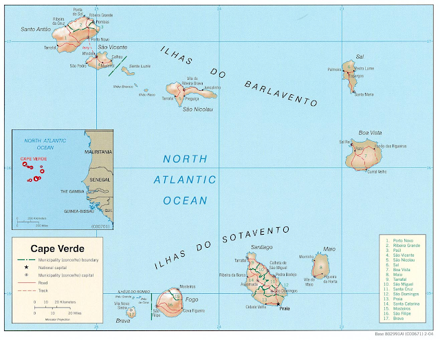
When I led my first Cabo Verde travel course in 2006, we spent all of our time on Santiago (which was fantastic) but we were not able to get to Fogo (which would have made a great trip even better). All these years later, we are finally doing it! Both islands will be part of my next travel course.

We are taking applications now for Geography of Coffee and Volcanoes in Cabo Verde. We will start on Santiago with an introduction to the country and its important role over five centuries connecting (in ways both terrible and wonderful) Africa, Europe, and the Americas. We will then fly to Fogo to learn about one of the world's smallest and most unusual coffee industries -- where the coffee is grown inside an active volcano. (Active means recently erupting, not currently erupting.)

This course is available for undergraduate or graduate credit (contact me directly if seeking the latter) and is open to BSU students as well as alumni, students at other universities, and other adults who want to have this learning experience. For BSU students, the class can count toward a major or minor in geography and toward minors in Cape Verdean studies, sustainability, or African studies. 

I use "we" above because this course results from deep collaboration with the Office of Study Abroad and the Pedro Pires Institute for Cape Verdean Studies. We will also be working closely with the University of Cabo Verde and the schools and municipal governments of the island of Fogo. Pre-departure meetings wil be both on campus in Bridgewater and via Zoom as I travel to Fogo for a coffee festival about a month before the trip itself.

Please apply now, using the following links.

Everybody can look at the program brochure for highlights of the trip. The $2,900 cost is the same for all participants, whether seeking credit or not. Also see syllabus for more details.

Current BSU students can apply by starting at the course application page. Please read it carefully!

People who are nod current BSU students needs to start by getting a Banner ID from the Take a Course page at the College of Continuing Studies.


This course will visit two of the Sotavento (Leeward) Islands.
See my Cabo Verde Basics post for introductory geography notes.


Wednesday, September 28, 2022

Buffalo and Other Climate Havens

Buffalo, New York declared itself a climate have in 2019 and has an Office of New Americans to facilitate its role as a place of welcome. In yesterday's episode of On Point, journalist Kimberly Atkins Stohr brings together an impressive array of guests -- from planners and scholars to a recent climate refugee in Buffalo itself -- to examine the many geographic implications of climate migration in America.

America’s Climate Havens of the Future begins with the story of Maria Agosto, a refugee from the eponymous hurricane that drove her from her home in Puerto Rico to her new home in western New York. On  Point is always worth listening to; this episode is worth listening to twice -- and taking notes. Some of its lessons are in my own notes below.

This photo from Isle of Jean Charles, Louisiana accompanies the podcast. As I mentioned in my 2016 article Climate Attack, this community may have been the first in the U.S. to be abandoned entirely because of climate change.

Sociology professor and demographer Matt Hauer describes lessons that are already beginning to be learned about the migration of humans because of environmental push factors. His own research focuses on migration that is likely to result from rising seal levels, and he is well aware that other consequences of climate change will also result in migration. Some patterns are counterintuitive, though: as dangerous as increased temperature itself is, a lot of migration is toward such urban heat islands as Atlanta and Austin, which exhibit pull factors that will continue to further their growth. 

His models estimate 13 million migrants resulting from rising sea level alone. During the interview, he explains why other serious hazards -- from wildfires to hurricanes -- do not necessarily drive significant migration. 

Beth Gibbons, executive director of the nonprofit American Society of Adaptation Professionals, says, "the past is no longer a good guide for what the future is going to look like." In some ways -- such as flood modeling -- the past is not even a good guide to the present.

Both Hauer and Gibbons note that a lot of migration continues to be stepwise -- people tend to move to nearby places where they might have some social capital before they make long-distance moves to places where they have little prior connection. The story of Maria Agosto and her family is an exception that may become increasingly common. Planners in Buffalo, in fact, are counting on it. 

The city is already known as a welcoming place and is embracing its potential as a climate haven. Even the most welcoming places are working to mitigate aspects of rapid growth on housing affordability, indigenous communities, suburban sprawl, and more.

During the program, Missy Stultz, sustainability manager for Ann Arbor, Michigan describes some specific ways in which her city is preparing for its role as a climate haven Geographers, by the way, are well prepared for exactly the kind of work she is doing. 

Gibbons points out that "legacy" (aka Rustbelt") cities of the north have the potential to benefit from climate-driven migration. She cites Detroit, whose population has declined from 1,200,000 to 700,000 and therefore has a lot of physical space for newcomers, but would need significant restoration of its infrastructure to return to anything like its former population.

She further describes how infrastructure investments can use both state and federal resources not only to accommodate new residents, but also to do so in more equitable and sustainable ways. Among the many specific details she mentions is the rarely discussed but increasingly dangerous problem of combined sewer overflow (CSO), which is just as nasty as it sounds. 

Lagniappe 

We have been here before, though for different reasons. The episode page includes a link to What Migrants Displaced By The Dust Bowl And Climate Events Can Teach Us, a 2018 article by Francesca Paris on Here & Now Compass.

Tuesday, August 16, 2022

Where the Party At?

 Geographers ask three questions: Where is it? Why is it there? So what? 

Followers of this blog know that I apply these questions to all kinds of things in both the human and natural realm. Today. write simply to share a "Where?" question with very little insight about the "Why?" or the implications -- at least so far.

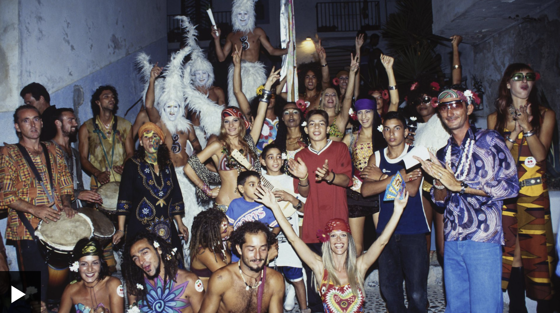
The hedonistic scene above is from a short video on BBC, representing decades of escalation in the party atmosphere of the Spanish island of Ibiza. I found it after hearing The Nightclub that Changed Ibiza, which was today's 4:50 am (Boston time) segment of Witness History. 

I think that this story got my attention because the place transitioned from a hedonistic counterculture to a place reserved for the extremely wealthy.

Since neither the audio nor the video include a map, I add one here. It does begin to address the "Why?" question. Ibiza is part of Spain, but far enough from the mainland to have served as a refuge in the Franco dictatorship. It is surrounded by water and by definition has the Mediterranean climate that is so good for relaxation: mild winters and low-humidity summers. The map also reveals that the island is part of the Balearic archipelago, which features several other party destinations.


Tuesday, August 09, 2022

Burn Pits of Iraq

On NPR's Morning Edition, journalist Leila Fadel interviewed anthropologist Kali Rubaii of Purdue University about her research into the ongoing health problems experience both by U.S. veterans and Iraqi civilians, because of the unregulated burning of mixed waste during the wars there.

In the 1970s and 1980s, newly emerging environmental laws were widely ignored on military bases in the United States. This changed at some point in the 1990s, personnel were retrained, and those bases began to come into compliance. The case of Iraq, however, highlights the long-term damage done by war.

Children in Mosul, from Professor Rubaii's 2020 article
Birth Defects and the Toxic Legacy of War in Iraq

This is a particularly difficult example that illustrates the severe damage done by long-term exposure to toxic chemicals. It is as if we either learned nothing from Love Canal or chose to ignore what we did learn.

City Champions

As I prepare a full slate of classes for the fall semester, I enjoy planning the weekly activities of Discovering Brockton, a First-Year Seminar I offer to students in the Commonwealth Honors program at Bridgewater State University. 

Class chat in Brockton City Hall. Photo: Brian Benson, BSU

In 2019, we were fortunate to have Brian Benson of our university publicity office join us for a day. His article City Champions remains the best summary of what we try to do in the class. 

For two semesters during the pandemic, I offered this class fully online. I was grateful that so many collaborators in the region helped me to have meaningful video class sessions in which they shared various facets of the community. Videoconferencing, however, did not provide the kinds of insights that arise from driving or walking around a place with a geographer. 

For that, I created a series of Windshield and Sidewalk Surveys, with the help of my artist son who happened to be visiting for a few weeks as the 2020 semester was about to begin. See the playlists Windshield Surveys, Sidewalk Surveys 1, and Sidewalk Surveys 2 to join some of the fun.

Lagniappe

Championing the City of Champions (2012)

Geographic Lens on New Bedford (2017)

Brockton Honors (2020)

Monterrey COIL Project: Livable Cities (2022)

And more news about the Department of Geography.

Students tour City Hall in 2007, the second time 
I offered this course. See my Geography of Brockton 
web page, which I can no longer update.


Sunday, August 07, 2022

Wall Street Over Haiti

 In The Ransom, NYT outlines nearly two centuries of interventions by France and the United States that -- combined with the collusion of internal elites -- have perpetuated debt and disarray in Haiti. Even coffee is implicated.

US Military in Haiti, 1920 Image: NYT


Blog Ideas

coffee (25) GEOG381 (24) GEOG388 (23) GEOG470 (18) climate change (18) GEOG130 (16) geography (16) GEOG332 (13) GEOG431 (12) musica (11) GEOG 332 (9) GEOG 381 (9) Mexico (9) Brazil (8) GEOG286 (8) Texas (8) education (8) migration (8) GEOG298 (7) borderlands (7) GEOG199 (6) GEOG331 (6) Massachusetts (6) US-Mexico (6) deBlij04 (6) immigration (6) GEOG 130 (5) GEOG 286 (5) GEOG287 (5) climate justice (5) cultural geography (5) fair trade (5) food (5) geographic education (5) nicaragua (5) water (5) Arizona (4) GEOG 171 (4) GEOG171 (4) GEOG295 (4) Safina (4) africa (4) deBlij05 (4) land protection (4) music (4) politics (4) Bolivia (3) Boston (3) COVID-19 (3) Detroit (3) Ethiopia (3) Managua (3) Obama (3) border (3) cartography (3) drought (3) libraries (3) pesticides (3) suburban sprawl (3) trade (3) unemployment (3) Alaska (2) Amazon (2) Bridgewater (2) Canada (2) Chiapas (2) China (2) Colonialism (2) EPA (2) EarthView (2) Economy (2) Environment (2) GEOG 199 (2) GEOG 287 (2) GEOG 388 (2) Google Maps (2) Government (2) Hawaii (2) India (2) Lexington (2) Maldives (2) Mozambique (2) NOLA (2) NPR (2) National Monuments (2) National Parks (2) New Orleans (2) Religion (2) Rio Grande (2) Taunton River Wild and Scenic (2) Tex-Mex (2) The View from Lazy Point (2) United States (2) Venezuela (2) anthropocene (2) cape verde (2) censorship (2) central america (2) chocolate (2) corn (2) deBlij07 (2) deforestation (2) demographic transition (2) demography (2) education reform (2) employment (2) environmental geography (2) film (2) forest fire (2) global warming (2) islands (2) landscape ecology (2) librarians (2) maps (2) organic (2) peak oil (2) refugees (2) sense of place (2) soccer (2) sustainability (2) television (2) water rights (2) whales (2) #bbc (1) #nicaragua (1) #sosnicaragua (1) #sosnicaragua #nicaragua (1) 100 Years of Solitude (1) ACROSS Lexington (1) Accents (1) Adam at Home (1) Alice (1) Alt.Latina (1) American Hustle (1) April (1) Association of american Geographers (1) Audubon (1) Aunt Hatch's Lane (1) BBC (1) BSU (1) Baby Boomers (1) Banda Aceh (1) Bay Circuit Trial (1) Bechtel (1) Beleza Tropical (1) Belize (1) Beloit College (1) Ben Linder Cafe (1) Bet The Farm (1) Bhopal (1) Biafra (1) Bikeway (1) Bikini (1) Bill Gates (1) Bill Moyers (1) Boeing 777 (1) Brazilian (1) Brazilianization (1) Bridge (1) British Columbia (1) Brockton (1) Bus Fare (1) Bush (1) Cabo Verde (1) California (1) Cambridge (1) Cape Cod Bay (1) Carl Stafina (1) Catholic (1) Ceuta (1) Chalice (1) Chipko (1) Citgo (1) Climate risks (1) Cochabamba (1) Colombia (1) Common Core (1) Commuter (1) Computers (1) Cuba (1) Cups and Summits (1) Dallas (1) David Byrne (1) Deans Beans (1) Delaware Valley (1) Dunkin Donuts (1) Earth Day (1) Earth View (1) Easton (1) El Salvador (1) Elizabeth Warren (1) Ellicott City (1) Emilia Laime (1) English-only (1) Environmental History (1) Euphrates (1) European Union (1) Evo Morales (1) FIFA (1) FYS (1) Fades Out (1) Farms (1) First-Year Seminar (1) Food Trade (1) Frederick Kaufman (1) French press (1) Fresh Pond Mall (1) GEOG 431 (1) GEOG 441 (1) GEOG213 (1) GEOG490 (1) Gabriel García Márquez (1) Garden of Gethsemane (1) Gas wells (1) Gateway Cities (1) General Motors (1) Gini Coefficient (1) Girl in the Cafe (1) Google (1) Gordon Hempton (1) Gravina Island Bridge (1) Great Migration (1) Great Molasses Flood (1) Guy Lombardo (1) Haiti (1) Hawks (1) Heart (1) Higher Education (1) History (1) Holyhok Lewisville (1) Homogenous (1) Honors (1) How Food Stopped Being Food (1) Hugo Chavez (1) IMF (1) Iditarod (1) Imperial Valley (1) Income Inequality (1) Indonesia (1) Iraq (1) Irish (1) Japan (1) Junot Diaz (1) Kenya (1) Ketchikan (1) Key West (1) Kindergarden Students (1) King Corn (1) Kiribati (1) Latin America (1) Limbaugh (1) Literature (1) Living On Earth (1) Louisiana (1) Love Canal (1) Luddite (1) M*A*S*H (1) MCAS (1) MacArthur Genius (1) Maersk (1) Malawi (1) Malaysia (1) Malaysian Air Flight 370 (1) Mali (1) Manu Chao (1) Map (1) Marblehead (1) Mary Robinson Foundation (1) Maryland (1) Massachusetts Bay Colony (1) Math (1) Maxguide (1) May (1) Maya (1) Mayan (1) Mayan Gold (1) Mbala (1) McDonald's (1) Melilla (1) Mexicans (1) Michael Pollan (1) Michelle Obama (1) Micronesia (1) Military (1) Military Dictatorship (1) Minuteman Trail (1) Mongolia (1) Monsanto (1) Montana (1) Morocco (1) Mount Auburn Cemetery (1) Muslim (1) NPS (1) Nantucket (1) National Education Regime (1) Native American (1) Native Americans (1) New Bedford (1) New Hampshire (1) New York City (1) New York Times (1) Nigeria (1) No Child Left Behind Act (1) Norquist (1) North Africa (1) Nuts (1) Oakland (1) Oaxaca (1) Occupeligo (1) Occypy (1) Oklahoma (1) Oklahoma City (1) Oppression (1) PARCC (1) Pakistan (1) Pascal's Wager (1) Peanut (1) Pearson Regime (1) Philadelphia (1) Philippines (1) Pink Unicorns (1) Poland (1) Portuguese (1) Protest (1) Public Education (1) Puebla (1) Puritans (1) Quest University (1) Rachel Carson (1) Reading (1) Republican (1) Retro Report (1) Robert Reich (1) Rock Legend (1) Ronald Reagan (1) Rondonia (1) Rosa Parks (1) SEXCoffee (1) Safety (1) Samoza (1) Sandino (1) Sara Vowell (1) Save the Children (1) Scotch (1) Scotland (1) Seinfeld (1) Senegal (1) Sergio Mendes (1) Severin (1) Sharrod (1) Silent Spring (1) Sinatra (1) Slope (1) Smokey the Bear (1) Somalia (1) Sombra (1) Sonora (1) Sonoran desert (1) Sonoran hot dog (1) South America (1) Spain (1) Stairway to Heaven (1) Storm (1) Suare Inch of Silence (1) Sumatra (1) Swamp (1) Tacloban (1) Tanzania (1) The Amazon (1) The Amazon Trail (1) Tigris (1) Tucson (1) Tufts (1) U.S Federal Reserve (1) U.S Government (1) U.S. economy (1) USDA (1) USLE Formula (1) Uganda (1) Unfamiliar Fishes (1) Union Carbide (1) Vacation (1) Vexillology (1) Vietnam (1) ViralNova (1) WNYC Data News (1) Wall Street (1) Walsenburg (1) Walt Disney (1) Walt and El Grupo (1) Ward's Berry Farm (1) West (1) Whaling (1) Wilson (1) Winter Storm Saturn (1) Wisconsin (1) World Bank (1) Xingu (1) YouTube (1) Zombies (1) agriculture (1) antitrust (1) aspen (1) austerity (1) aviation (1) banned books (1) bark beetle (1) bean (1) beavers (1) bicycle (1) bicycling (1) bike sharing (1) binary (1) biodiversity (1) bioneers (1) books (1) boston globe (1) cacao (1) cafe (1) campaign (1) campus (1) cantonville (1) capitals (1) carbon dioxide (1) carbon offsets (1) carioca (1) cash (1) cashews (1) census (1) chemex (1) chemistry (1) chronology (1) churrasco (1) civil rights (1) coffee grounds (1) coffee hell (1) coffee prices (1) coffee quality (1) college (1) compost (1) computerized test (1) congress (1) conservation commission (1) corporations (1) countries (1) cubicle (1) dams (1) deBlij06 (1) deBlij08 (1) death (1) deficit (1) development (1) dictatorship (1) distracted learning (1) distraction (1) drug war (1) dtm (1) earth (1) economic diversification (1) economic geography (1) election (1) embargo (1) energy (1) enhanced greenhouse effect (1) environmentalist (1) ethnomusicology (1) exremism (1) failed states (1) farming (1) financial crisis (1) football (1) forestry (1) forro (1) fracking (1) free market (1) free trade (1) fuel economy (1) garden (1) genocide (1) geography education (1) geography games (1) geography of chocolate (1) geography of food (1) geologic time (1) geotechnology (1) gerrymandering (1) global pizza (1) globe (1) goodall (1) green chemistry (1) ground water (1) guacamole (1) guatemala (1) habitat (1) high-frutcose (1) home values (1) hospitality (1) hourglass (1) housing (1) hydrology (1) illegal aliens (1) income (1) indigenous (1) interfaith (1) journalism (1) kitchen garden (1) labor (1) language (1) libertarianism (1) library (1) linguistics (1) little rock (1) llorona; musica (1) macc (1) maccweb (1) magic realism (1) maple syrup (1) mapping (1) masa no mas (1) massland (1) medical (1) mental maps (1) mi nina (1) microlots (1) microstates (1) mining (1) mltc (1) monopoly (1) municipal government (1) nautical (1) neoclassical economics (1) new england (1) newseum (1) newspapers (1) noise pollution (1) pandas (1) petroleum (1) piracy (1) pirates (1) poison ivy (1) police (1) political geography (1) pollution (1) provincial government (1) proxy variables (1) public diplomacy (1) quesadilla (1) rabbi (1) racism (1) real food cafe (1) regulations (1) remittances (1) resilience (1) resistance (1) respect (1) rigoberta menchu (1) rios montt (1) romance (1) roya (1) runways (1) russia (1) satellites (1) science (1) sea level (1) selva negra (1) sertao (1) sertão (1) sex (1) sex and coffee (1) simple (1) sin (1) smokey (1) solar (1) solar roasting (1) south africa (1) sovereignty (1) species loss (1) sporcle (1) sports (1) state government (1) taxes (1) tea party (1) teaching (1) textile (1) texting (1) tortilla (1) training (1) transect; Mercator (1) travel (1) triple-deckers (1) tsunami (1) urban geography (1) utopia (1) vermont (1) vice (1) video (1) wall (1) water resources (1) water vapor (1) whiskey (1) whisky (1) widget (1) wifi (1) wild fire (1) wildfire (1) wildlife corridor (1) wto (1)