Showing posts sorted by relevance for query human sieve. Sort by date Show all posts

Monday, November 27, 2017

ESRI: Envisioning the Embattled Borderlands

PLEASE CLICK MAP for a BETTER VIEW
The map (above) that ESRI geographer Krista Schlyer chose for the top of her photo-map essay response to the so-called border wall is indicative of the care she and the rest of the ESRI team have taken with this entire exhibit. As a geographer who lived in this map for seven years (1990-1994 in Tucson and 1994-1997 in Pharr), I notice a few important things that this map captures nicely.

First, the borderlands are identified by the border, but not strictly defined by it. As Oscar Martinez argues in Border People, it is a zone that extends approximately 100 miles in each direction from the line that gives the region its identity. In every sense except strict legalities, this region is neither the United States nor Mexico. It is a third entity that is both divided and united by a line that meanders through its center. In addition to Border People, I recommend Tom Miller's On the Border as an introduction to the place; I had the privilege of knowing both writers during our Tucson years.

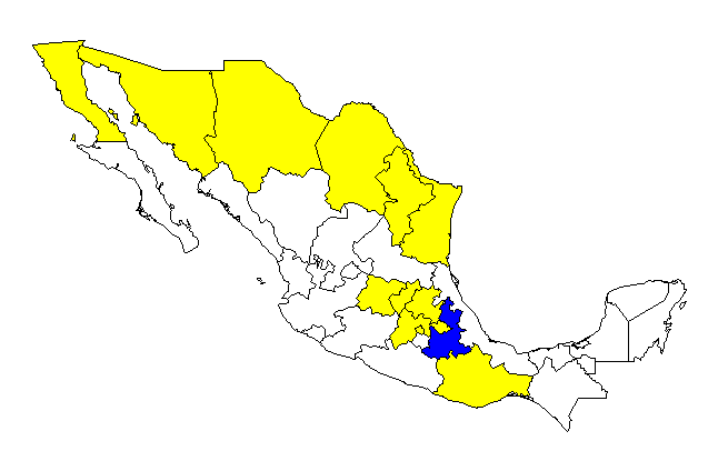
Second, the United States of America and the United States of Mexico are both federal republics comprising a number of states (50 and 31, respectively, plus a federal district in each). For people living in the border region, connections between neighboring states are important. Residents of California, Arizona, New Mexico, and Texas become familiar with Baja California, Sonora, Chihuahua, Coahuila, and Tamaulipas.

The cultural and environmental landscape of the border is not well understood by pundits and demagogues who make their living from caricatures of it. The misguided policies that result threaten real damage and will deliver no benefits.

ESRI's Krysta Schlyer has made an important contribution with this well-researched borderlands geography project.


The embedded version of this project condensed -- see the full Embattled Border story map here.

More about borders and The Border from this Environmental Geography blog

The threats posed to the people and environments of the border by outside demagoguery have certainly increased under the current administration, but in many ways are a continuation of a militarization of the border that was under way when I was living in Arizona. Although my own writing on the topic has become more focused in 2017, my earlier writing could also be instructive. I think that my "human sieve" metaphor is especially important, and that the wall is part of a broader effort by politicians who prefer to choose their voters, rather than to allow the opposite to transpire.

Each of these posts includes links and images to the work of many journalists, artists, and geographers.

Take Our Jobs, Please (June 2010)
The Border: A Human Sieve (June 2010)
Murder City (November 2010)
Where Are the Humans? (November 2011)
No se olviden Mexico (June 2012)
Precious Progress (November 2012)
Economic Baggage (April 2014)
Why Walls Won't Work (November 2014)
Not One Human (August 2015)
Hiring Humans (February 2016)
Borders: What's Up With That (August 2016)
Border IRL (November 2016) -- includes a map of all of my border crossings
Bridges and Habilitation (July 2017)
Through the Wall (October 2017) 

Saturday, November 19, 2011

Where are the Humans?


It is hard to know what counts as a human being any more. As the Occupeligo has helped a much broader part of the population understand, it is not necessary to be a person at all, in order to be human, as many corporations could tell you. If they were people, that is.

As I wrote in my Human Sieve post last year, an increasingly greedy and xenophobic nation wants the labor of immigrants but not the immigrants themselves. Though most Americans do not yet take this as far as Mitt Romney has, there is a growing interest in narrowing the definitions of "person" or "citizen" to include only one's self and one's closest associates.

I was a fan of the Saturn car company from its inception to its untimely demise, only because it seemed genuinely to be working toward human-to-human relationships among people with many different roles, from designing and assembling the cars to selling and buying them. A formative experience for me, in fact, was watching a Saturn training video in which a man explained that he was so glad to have come to Saturn from a previous employer (another General Motors division) where he was "hired from the neck down." At Saturn, he brought not only his arms, legs, and back to work, but his mind and soul as well. Unfortunately, the room for such a brand in the GM stable appears to have been limited.

Just as it can be disheartening to be considered a one-dimensional worker, so, too, is it problematic to be thought of solely as a consumer. At some point after World War II, consumerism grew from being simply a lot of consumption into being a genuine -ism, which is to say a world view that is wrapped around consumption.

At some point the meaning of "shopping for the holidays" shifted -- for an alarming number of people -- from "shopping as part of the preparation for enjoying the holidays" to "shopping as a holiday." When the shift from "person" to "consumer" has gone this far, it has in fact gone too far.

As with many things in the U.S. these days, the trend seems to be bifurcating. Despite an economy that is foundering and environmental systems that are becoming unraveled, many people find themselves in a race to consume ever-more stuff, though they might not even have a place to put it all. Others, however, reject the idea that they should participate in their own objectification, and refuse -- as my family has done for two decades -- to purchase anything at all on Thanksgiving or the day after. These are days for feast and famine, and maybe a film and some music, but in our house, the day after Thanksgiving is BUY NOTHING DAY.

All the world is a stage, they say, but we might not even be players. The consumers who choose to play in the arms race of ever-earlier holiday openings and the workers who are forced to play along are more puppet than actor. When the invisible hand of the market is not pleasuring itself under the sheets of the global economy (as Carl Safina has so artfully written), it is busily working the strings of a marionette show whose point is increasingly obscure and whose ticket price is ever-growing.

Tuesday, June 22, 2010

The Border: A Human Sieve

The United States is a nation of immigrants. It is also a nation of immigrant bashing. Always has been. With each economic downturn, a new generation of recent immigrants becomes the scapegoat, even as those of a generation or two ago are venerated as simply industrious. With each economic upturn, the convenience of underpaid labor helps people to forget their indignation about what -- and who -- is legal.

http://notexasborderwall.blogspot.com/
As a geographer who has lived in Mexico, the United States, and that "in-between" land along the border, I think constantly about the real implications of the rhetoric. This is especially true as the pendulum is swinging a bit further as the recession/depression stretches out, and because the rhetoric is hardening -- quite literally hardening into a set of massive walls that will sever the human and physical geography of the borderlands for generations or centuries to come. If the wall resembles a tomb stone, it is because it marks the death of a vibrant, little-understood place -- a couple thousand miles long but only a few miles wide.

The 1994 book Border People by my former church mate Dr. Oscar Martinez provides a thorough and enjoyable explanation of the history and human geography of this unique place. The one gap is that he does not recognize the role of "snow birds" -- tens of thousands of retired, mainly Anglo northerners who flock to the border region each winter, where they are present in abstentia, in a sort of gated archipelago. It would be very interesting to study these enclaves in the midst of the current turmoil. Our friend Tom Miller's classic On the Border is a traveler's celebration of the very linear region, as he traversed each and every available crossing at the time of his writing a generation ago.

The U.S.-Mexico border has, of course, become something very different from what it was when I lived, studied, and worked in the borderlands from 1990 to 1997. In those days, it was already the case that nowhere in the world was a greater income gap to be found across an international border. It was not idyllic -- begging, vice, and violence were facts of life. But so, too, were a wide range of ecological, cultural, and economic connections that knitted the region together. Today, demand for drugs in the U.S., corruption in governments on both sides, and a free flow of weapons from an unregulated U.S. market have combined with truly onerous economic conditions in Central America and the interior of Mexico to create a truly nightmarish landscape. It is a landscape toward which people are pressed, from as far south as Chiapas or Nicaragua, lured by the false hope of a few factory jobs on the Mexico side of the border, and many more in Houston, Omaha, and even Belmont, Massachusetts.

The results are gruesome -- children living in dangerous tunnels, women killed on the way home from work, people dying in the deserts, and assassinations so common that a New Mexico librarian has become a hero simply by trying to keep a count of them.

Because the border wall will never be an absolute barrier -- the fantasies of Rush Limbaugh and Newt Gingrich notwithstanding -- I think another metaphor may be even more apt than the tomb stone: that of a sieve. It effectively separates the human worker from the human being. Just as Mitt Romney wants cheap labor to cut his grass but no underpaid workers to vote against him for president, so the entire power structure benefits from a series of barriers that allow for the free movement of capital and the furtive movement of labor, but not the free movement of political rights or moral entitlements.

Ron Paul's son, the radical candidate for U.S. Senate Rand Paul, admitted to precisely this in May, when he said,
“I’m not opposed to letting people come in and work and labor in our country. But I think what we should do is we shouldn’t provide an easy route to citizenship. A lot of this is about demographics. If you look at new immigrants from Mexico, they register 3-to-1 Democrat, so the Democratic Party is for easy citizenship and allowing them to vote. I think we need to address that."
The lack of outcry at this remark is a sign of just how far the pendulum has swung. Proponents of the border wall may come in many sizes, shapes, races, and income levels, but it would not be built if it were not serving the needs of the overclass -- those who really benefit from the division of labor in the world space-economy. Even executives of the regional banks in the Rio Grande Valley of Texas have not been able to stop the construction of the wall -- for they know it will harm regional business immeasurably -- because of the service it provides to global capital. (And global capital gives the rest of us enough cheap toys -- and cheap coffee -- that we tend to play along.)

I conclude this post with a passage from the opening pages of Richard Thurman's Jesus and the Disinherited. Thanks to my friend John McClintock for bringing it to my attention. Thurman first wrote this in the context of the oppression of African Americans in the 1940s; my friend John -- a military veteran, BSC philosophy graduate, and divinity student -- selected it in the context of a Memorial Day sermon about war; and I see it as deeply relevant to the discussion of how a wealthy, mostly Christian nation treats those who work to create its comforts, both at home and far away. I had the honor of reading this passage at the beginning of John's sermon at First Parish Church in Bridgewater.

Rev. Thurman wrote:


To those who need profound succor and strength to enable them to live in the present with dignity and creativity, Christianity often has been sterile and of little avail. The conventional Christian word is muffled, confused, and vague. Too often the price exacted by society for security and respectability is that the Christian movement in its formal expression must be on the side of the strong against the weak. This is a matter of tremendous significance, for it reveals to what extent a religion that was born of a people acquainted with persecution and suffering has become the cornerstone of a civilization and of nations whose very position in modern life has too often been secured by a ruthless use of power applied to weak and defenseless peoples.


Learn more about Christian perspectives on immigration from Christians for Comprehensive Immigration Reform.

Lagniappe -- 2019 update

The pressure to harden the border has become much more intense. Many local residents in the borderlands continue to resist, on a bipartisan basis. See articles from Big Bend and Butterfly articles for just two of the many examples.

Tuesday, February 02, 2016

Hiring Humans

Some employers seeking to avoid the provisions of the Affordable Care Act have learned an interesting lessons about their workers and their businesses. The focus is on employment in fast-food, which is often cited as a sector that requires no skills. As a former master of the fryolater, I listened with interest. Decades before ACA, I knew my employers would rather hire 20 half-humans than 10 full humans.
All workers have value.
In this report, even the b-school consultants who assist employers in short-term cost-cutting are starting to rethink the proverbial race to the bottom as a management strategy.
The story is worth a careful listen. From it I take three lessons:

  1. There is no such thing as unskilled labor.
  2. Businesses benefit when they treat people as full humans.
  3. Despite the free-market ideology of its opponents, the lack of universal health care is itself a market disruption. ACA is a compromise that only partly addresses this.
In the following countries, health care is not a factor in deciding how to employ people:

The most intriguing characters in the story about health care are the fast-food managers. They are situated between the employers and most of the employees, having to negotiate difficult choices for workers who want to earn as much as they can, without earning too much to qualify for state aid. By subsidizing these workers, the state is actually subsidizing the restaurants, but the workers voluntarily limit their income to ensure that the subsidy remains in place.

Lagniappe

The fry basket at the top of this story is a sieve, which is an apt metaphor for anti-human policies and practices related to labor, migration, and health care. A "human sieve" search on this blog leads to other posts about the problems that arise when greed tries to separate work from the humans who do it.

Saturday, August 29, 2015

Not One Human

When I was a high school student in Kansas City, Missouri, our history class included a great deal about the importance of Missouri in the Civil War. To hear my teacher tell it, Missouri is where the outcome really was determined. During my time in the Show Me State, I spent a couple of weeks in Columbia ... long enough to know that "Cruisin' the Loop" was the main weekend activity.

These Missouri memories came together for me today, as I learned about a very geographic scandal in the capital.

The scandal involves a peculiar case of gerrymandering, an all-too-common phenomenon by which politicians try to choose their voters instead of risking the opposite. I have written about the practice extensively on this blog, especially in the 2010 post Article One: Enumeration.

This quasi-governmental business district includes just one voter.
But its goal was to include zero.
The Columbia case goes far beyond the usual tricks in which geographic skills are put to sinister uses. The usual idea is to create legislative districts that will maximize the numeric advantage of incumbents. This is reprehensible and counter to the intent of the Framers of the Constitution. It turns elections into a game, a game in which the odds are stacked in favor of the house. But at least it is a game that allows humans to vote.

The Missouri scheme tried to go a step further. Business "leaders" along the Loop in Columbia conspired to draw a boundary around a "community improvement district" in such a way that humans would not be able to vote at all. If they could achieve that, Missouri law would allow the right to vote to transfer to the businesses themselves. The fact that Missouri allows voting to default to businesses if no humans are available suggests that this scheme might have a precedent.

The reasons for the scheme were complicated, and apparently they hoped nobody would notice. They formed the district in order to make some shared capital improvements. They even used it to levy a small property-tax surcharge on themselves.

The bulk of the improvements, though, would be paid (or more accurately, repaid -- they already spent the money) by a special sales tax. In addition to shifting the cost of capital improvements to retail customers in this way, the businesses (some of which would not even have customers affected by the tax) would be able to pay an executive director with those funds.

It was because they feared voters would not approve such a regressive form of taxation -- Robin Hood in reverse, really -- they conspired to make sure no humans would get to vote on the matter.
Taxation without representation. We had a little set-to about that in Boston a while back.
It is that executive director who comes out looking the worst when they discovered that the evil clever geographers involved in this scheme might have been evil enough, but they were not clever enough. They allowed a single, pesky human to be included in the district. Jen Henderson is a student renting an apartment in the district who is not only a voter, but also an informed voter. She was pressured to disenfranchise herself so that "voting" would revert to businesses. (Scare quotes used because I still believe voting is something that only human citizens can do.) Once she learned what a serious game she was now part of, this young citizen took her civic duty very seriously and learned all she could about the issues involved. She has not announced how she will vote, but she has made it very clear she WILL vote.

Politicians who seek to disenfranchise voters are sometimes called "conservatives," but they really have no interest in conserving "American values" of democracy. Rather, they eschew Lincoln's words about the purpose of the Civil War, which was to ensure

"that government of the people, by the people, for the people, shall not perish from the earth."

Although the Columbia case could be dismissed as a quirky story with only very localized impact, it is indicative of a political climate in which the humanity of individuals is systematically separated from what they can provide in practical terms. The rights to vote, express opinions, organize, and peaceably assemble are essential aspects of our humanity.

They are increasingly separated, however, from our ability to provide work or, as it turns out, pay taxes and fees. My essays on immigration and the human sieve describe this phenomenon in the arena of immigration policy, in which labor somehow crosses the border, but civil rights remains on the other side.

Wednesday, November 26, 2014

Why Walls Won't Work

Because Congress rarely acts on immigration, presidents always do, couching "amnesty" in whatever terms they find most suitable, whether focusing on the work ethic of immigrants as Ronald Reagan did, or on the cohesion of families, as Barack Obama has done. Nothing belies putative commitments to "free markets" and "family values" more than the nasty treatment of millions of migrants who lack documentation.

Economies undergo cycles, and so does xenophobia. When the economy is strong, immigration is not considered a problem. When the economy is weak, current migrants become scapegoats, while previous generations become icons of long-lost virtues. When the economy is savaged -- as it has been in recent years by an unregulated cadre of financiers and other gamblers -- the scapegoating becomes savage as well. The labor of the undocumented is always welcome, of course, but their humanity is not, as I have written extensively with respect to the "human sieve" effect in general and the Mitt Romney phenomenon in particular.
Berlin Wall in 1989. As Stephen Green has explained (as quoted by James Joyner), "The Berlin Wall did not just fall down. It was torn down. It was torn down by the very people it was meant to cage."
All of which is to say that although Barack Obama has deported more people than any previous president and has continued to invest billions of dollars into walls both steel and electronic, "border security" remains a clarion call, and it means: "Ain't no wall high enough."

This mantra assumes many facts not in evidence, no matter how often it is repeated. My Sieve Details post refers readers to the work of Roque Planas, who explains the many problems with over-reliance on the giant walls, including their likelihood of increasing the amount of time individual migrants spend on this side of the border.
Most migrants are not coming over or under walls.
Reporting for WGHB's The World, Monica Campbell provides an additional reason that the southern wall "works" only for the contractors who scare Congress into over-funding it. With migration from Mexico in decline, Asian-Americans are now the fastest-growing group of undocumented Americans. And as anybody paying attention in the Boston area know, Obama's executive order will affect plenty of western Europeans as well.

This is not to suggest that one population should be substituted for another as scapegoats until the bankers give us our economy back. Rather, it is a reminder that debates that affect the lives and livelihoods of millions of our neighbors are often based on a willful ignorance of basic facts about them. I recently had the privilege of hearing a presentation by Pulitzer-winning journalist Jose Antonio Vargas, director of the film Documented. He was brought here from the Philippines as a child and is now making the case that immigration should be treated as a long-term civil-rights cause, rather than a short-term legal problem. Nothing is going to change about our economy's proclivity for drawing in migrants, so something needs to change about the treatment of the humans in our midst.
In closing, a word from our sponsor.

Friday, September 12, 2014

Sieve Details

I have long argued that U.S. border policy serves as a human sieve, detaining persons while allowing their labor or wealth to flow. I have written about many other aspects of misguided policy -- and misplaced thinking -- about migration.
Commerce continues at what used to be my favorite crossing point -- 100 km south of Tucson, between Nogales, Arizona and Nogales, Sonora, but under increasingly militarized conditions.
From Tucson, we moved to Pharr, Texas, where we had bridges directly into Tamaulipas.
I am very thankful to Roque Planas for his eloquent discussion of how to fix migration. He goes farther than I have done, but he makes the case quite clearly. Nothing about our current approach to migration policy is worth saving. Scrap it all, he says, and provides 16 compelling reasons. I would challenge skeptics to think very seriously about his reason #10: hardened borders serve as a kind of ratchet. The harder it is to get in, the more likely people are to stay once they arrive. His ethical and economic reasons are even more compelling in my view, but #16 points to one of the biggest obstacles: some people make a handsome income from unreasonably limiting the freedoms of the rest of us.

Wednesday, April 02, 2014

Economic Baggage

For almost as long as I have been a geographer, I have asserted that the border between Mexico and the United States is the steepest in the world in economic terms. Mexico is figuratively far from the poorest country on earth, but it is literally very near one of the richest. As I've written in Human Sieve and elsewhere on this blog, the human cost of this disparity is enormous.

From my favorite librarian I learned that at least one border is steeper, and the reality of life at that border -- especially for women -- is difficult to believe. Spain meets Africa directly in two Moroccan port cities -- Ceuta and Melilla -- exclaves that are on the African continent but legally part of the European Union. It is, in fact, EU security rules that have created an unthinkable level of despair on the edges of the town of Melilla.


As detailed in Suzanne Daley's excellent reporting in the New York Times, Melilla is quite literally a Borderline Where Women Bear the Weight. Morocco is not the poorest country in Africa, nor is Spain the richest country in Europe, but the income disparity between the two is about twenty-fold -- a disparity about five times greater than the gap between Mexico and the United States.

Because a loophole in the customs rules provides for a tax exemption for any cargo than can plausibly be considered "luggage" and parcels up to 100 kilograms are considered to meet that criterion, carrying large parcels across the border, pretending it is luggage, is the only viable employment for many Melillans.

Because jurisdictions between private and official security forces in the two countries are muddled, no authorities are willing to protect the women who have been pursuing this trade from trampling by men who are turning to this difficult work in greater numbers.

The women of Melilla compete with each other and with men for the opportunity to be the world's most oppressed baggage handlers.


Saturday, December 16, 2017

Putting Voter Suppression on the Map

As I mentioned in Dying to Vote after watching Selma last year, fear of black voters was the main motivator of those who violently opposed the civil-rights movement. Overcoming obstacles to the vote likewise became the chief concern of the movement. A half-century after the shameful events in Alabama, we all celebrate a narrow victory over bigotry in Alabama that would have been won by a wider margin, had the spirit of Bull Conner not continued to guide the state's political leadership.

The current "Weekend Read" article by the Southern Poverty Law Center is essential reading for anybody who is interested in the foundational concept of one person, one vote. That is, it should be essential reading for everybody. It details the many ways in which political elites in Alabama continue to work against the voting rights of African Americans. It is a very well-researched article, full of links to careful documentation of its alarming claims.

The 2013 reversal of key provisions of the Voting Rights Act led to predictable -- and predicted --outcomes. Alabama was among the first states to follow the Supreme Court's dog whistle, and to enact rules touted as preventing voter fraud but calculated to suppress votes.

An example can be found on the map of states in which a required photo-ID cannot be obtained, because of the closure of licensing offices. The U.S. Department of Transportation has confirmed what those who know Alabama can discern right away: this map disproportionately favors white voters.
Map: Kyle Whitmire
As blogger Kyle Whitmire of AL.com discerned by making his own map, the closure of licensing offices was guided by race. Just as a driver's license became essential to exercising one's Constitutional right to vote, the state closed licensing facilities in 8 of the 10 counties with the greatest proportion of minority voters, including many counties in the state's famed Black Belt, a region (shown in blue below) that voted most heavily for Doug Jones in the recent special election for the U.S. Senate.
Narrow victory over voter suppression.
Map: New York Times
The state did not limit its voter suppression to the one-two punch of requiring drivers licenses and then selectively closing the offices where they could be obtained. Ironically, Secretary of State John Merrill argued against the automatic voter registration that many states now attach to those very same licenses. Apparently in complete ignorance of the 26th Amendment to the U.S. Constitution, he argued that "just because you turned 18 doesn't give you the right to do anything."

Alabama is not the sole exponent of voter suppression in the U.S., of course, nor has the practice historically been limited to one party or the other. As the demographics of the country shift toward more racial diversity, however, the use of maps, registration rules, immigration law, and criminal law to suppress votes increases.

All of these tools are increasingly favored as ways for politicians to choose their voters, rather than taking the risk of allowing the reverse to happen. My Bad Salamander post cites some particularly egregious examples of mapping with political intent; my Embattled Borderlands and Human Sieve posts, while not specifically about voting, hint at the political uses of immigration policies.

Lagniappe

Although many of Roy Moore's partisan supporters argued that the "voters of Alabama" should settle the question of whether the accused pedofile should serve as a U.S. Senator, they are now working feverishly to suppress those voters for just long enough to preclude their input on a "tax bill" that will restructure wealth distribution, environmental protection, health care, reproductive rights, and much more. Sen. Mitch McConnell -- who initially opposed Roy Moore -- is now rushing the bill through the senate, while delaying the seating of Senator Jones, a well-known nemesis of the KKK.

Tuesday, November 20, 2012

Precious Progress

For prints, see WildNatureImages
We spent the first four years of my doctoral program enjoying the vibrant, desert life of Tucson. That program took eight years, which is why we are not as much fans of the university as we are of the city. At the time Tucson was a less-sprawly, somewhat more progressive version of Phoenix, closer to the border and with a lot more wild lands nearby.

We have been very distressed, therefore, to learn that the always severe politics of the state had become downright vicious, with many measures echoing the kinds of social control that have constrained Palestinians or South Africans. I have written about my distress in a series of posts, beginning a couple of years ago with Just Like Arlo and Human Sieve, which focus on the ways in which border "security" measures attempt to disembody cheap labor.

Curtis Acosta
This year, I have written about a number of developments, starting with a Tucson Teach-in that we held in February, in which we discussed how the state-wide political movements were having very specific impacts on students in the Mexican-American Studies program in Tucson. (See all of my Arizona posts for more details.) We centered that discussion on a viewing of Precious Knowledge, one of whose heroes is Curtis Acosta. A decade ago, when the School Board of the Tucson Unified School District wanted to narrow the gap in achievement and engagement of Mexican-American students, Mr. Acosta was part of a team that implemented a remedy that actually worked by establishing just one course in Mexican-American Studies. Students excelled not only in this more relevant course, but in their other studies as well.

Instead of getting awards, though, the teachers and students were attacked for introducing race into what many outsiders asserted had been a race-free setting. Of course, race had been a factor all along, and the work of these teachers actually allowed for some important and constructive discussions that freed students to do some real learning. The film documents the pressure on this and similar programs, at both the state and district level, and the eventual success of the curriculum's opponents. It was clear that just as one arm of a radical political movement worked to strip away civil rights for many Arizonans, another arm was determined to shut down any critical thinking about such measures. In the view of some activists on the right, schools were to be used to indoctrinate students that they were not experiencing discrimination.

The film ends grimly, but the story did not end with the film. When I was in Tucson, I was part of winning a few civil-rights battles, and apparently the ability to work together on matters of justice is still alive and well in Tucson. The work I did had very little to do with trying to elect particular candidates, because my preferred candidates never had a chance of winning. So in those days we got a lot done by working with whatever officeholders were in place. In this case, however, it was clear that more attention needed to be paid to the composition of the school board. Three individuals were undoing a major, successful initiative of an earlier board, and undermining the education of thousands of students in the process.

Juarez, Foster, and Grijalva, TUSD
School board elections really matter!
This fall, Camy Juarez and Kristel Foster were endorsed by teachers, and were elected to join Adelita Grijalva, who continues to serve and who had been the sole advocate for Mexican-American Studies on the most recent configuration of the board. Two members remain who had worked to dismantle Mexican-American Studies, but they will no longer have the votes to sustain such destructive measures.

All of this is by way of background for some very positive recent developments, reported by David Safier on Blog for Arizona. As a result of litigation that predates the above-mentioned drama -- and has been going on since before we arrived in Tucson in 1990 -- a court-mandated desegregation plan is near final approval. It includes a lot components that one would expect in such a plan, related to the location of attendance boundaries and the relationships among feeder schools.

It also mandates that "culturally relevant courses of instruction designed to reflect the history, experiences and culture of African American and Latino communities" be included as core courses at the high school level. In fact, implementation of this requirement will include similar components at the middle and elementary levels, as explained in Safier's overview of the plan. The plan does not necessarily require the return of the specific program described in Precious Knowledge, but in extended comments submitted to the blog, teacher Curtis Acosta expresses genuine optimism.

Wade Davis, quoted by Trying God's Patience/FB
The good news from Tucson came just as I noticed this online poster, which I have dubbed "Most succinct geography lesson." It is a lesson, sadly, that those running education in Tucson for political purposes in recent years have not yet learned.

Friday, June 25, 2010

Take Our Jobs. Please.


I am very fond of the United Farm Workers (UFW). In our household we "thank the farmers" daily for the food we eat and the coffee we drink. We do our best to maintain direct connections to farmers, but it is not always possible, and we know that this often means they are not adequately compensated for their difficult, skilled work.

The UFW has been at the forefront of protecting farm-worker rights, and when we lived in South Texas, we had the privilege of getting some of our produce directly from the local UFW organization, which offered a weekly delivery of the harvest.

My recent human sieve article described the ways that immigration laws are designed to separate a person's labor from his or her humanity and citizenship. I mention that senate candidate Rand Paul has specifically acknowledged this way of thinking, whereas fellow "conservatives" such as Mitt Romney are careful not to admit that this is precisely what they do.

Today a friend told me of a campaign by the UFW in which workers -- including many undocumented -- are taking the fight directly to their critics. The Take Our Jobs campaign will start formally on the Stephen Colbert show on July 8. Quite simply, the campaign invites unemployed citizens and documented workers to take their jobs. A few might be willing, but I doubt they will have many takers. The rest of us might be reminded that every time we enjoy good food at a low price, we should remember one thing:


THANK THE FARMERS!

Thursday, June 21, 2012

No se olviden Mexico


No se olviden Mexico, Mexico, mi Mexico
Mi Mexico

This is the plaintive cry as the music fades in Carlos Santana's Africa Bamba, his celebration of the rich diversity of the Americas: "Do not forget Mexico, my Mexico."
Mexico is the first place I visited in Latin America, and I was a close neighbor throughout most of the 1990s, first in southern Arizona and then in WAY southern Texas. I have since spent more time in Nicaragua and Brazil and elsewhere, but Mexico is never far from my mind, particularly over the past week or two. It has actually been impossible to forget, as the country has been in the news in so many important ways over the past week or two.
The states of Mexico I have visited, beginning with a quick
trip to Ensenada circa 1985.
This post is an attempt to bring together several disparate threads relating to a country whose fate -- whether any of us wishes this or not -- is interwoven with that of the United States. The far right in the United States has managed to paint Mexico as the root of financial devastation that began much farther north, while Mexico itself continues to derive both much of its pain and much of its gain from proximity to a northern neighbor that views it mostly in terms of well-worn stereotypes.

The Summit
When world leaders met in 1944 to write the rules for the world economy, they gathered at the Mt. Washington Hotel in New Hampshire in a conference known as Bretton Woods. (Readers can decide for themselves whether this intercourse was more or less transgressive than that of Rob Lowe and Jodie Foster in the other Hotel New Hampshire). All 44 of the Allied countries that had opposed Germany, Japan, and Italy in World War II agreed at that point to create the World Bank, the International Monetary Fund, and the General Agreement on Tariffs and Trade (GATT, which would eventually spawn the World Trade Organization, WTO).
Both Mexico and Brazil were represented in that initial meeting, but in subsequent decades such important matters were discussed in much narrower circles, often excluding those most affected. Both G7 and G8 (Group of 7 or 8, depending on whether the Russians were invited) drove the proverbial bus for many years, until they landed it in a colossal ditch of bank deregulation in 2008. At that time, the fig leaf of eight-country consensus was inadequate to the exposure, so a broader group of leaders was called together -- the G20 included such emerging economies as Mexico, Brazil, India, and China in a meeting that is sometimes called Bretton Woods II. Depending on one's point of view, the summit averted financial catastrophe or perpetuated an imbalance of power in favor of banks, or perhaps both.
Leaders of the G20 met in Mexico last week, with very low expectations and the predictable meager achievement of minimizing the damage thought likely to emanate from Europe. The kinds of crises that once threatened collapse only from the periphery now routinely infect the core, but no challenge to economic orthodoxies are yet forthcoming. Even Mexico, which was the host country and nominal "president" of the meeting, made only the feeblest of entreaties for IMF support of debt relief. The outcome was a predictably vague commitment to fostering growth, with no clear vision of how to do this or even whether it is desirable.


Clarification: Although 2008 marked a dramatic expansion in the importance of the G20, it had in fact first met in 1999. Geographer Matt Rosenberg describes the group's evolution in more detail on his What is the G-20? He mentions several other economic groupings and lists the five countries invited to this year's meeting by Mexico.


Chiapas and Greenwash
The latest G20 meeting took place almost simultaneously with a United Nations summit in Rio de Janeiro (described in more detail in a Brazil post I completed earlier today). Again, expectations were low, as leaders focus on short-term crises in the world's financial apparatus, to the exclusion of far deeper crises in the biosphere itself. And those expectations were met, with countries trumpeting environmental euphemisms rather than grappling with environmental realities.Writing for Triple Crisis, Timothy Wise charges that many of the food-security programs trumpeted by Mexico's at G20 are far less than real.
A further coincidence is that this all takes place just as two young friends have headed to Chiapas for a documentary film project that delves into the very real costs of empty environmental promises. Their blog CO2lonialism and the Green Economy examines the sometimes false promise of carbon offsets. Even when working honestly, these arrangements assuage first-world guilt by protecting forests to absorb carbon equivalent to that emitted by our own profligacy. But in Chiapas --- home both to Mexico's most marginalized indigenous communities and its most abundant biodiversity -- even that promise is not met.
Incidentally, as I discuss these and other matters with students in my Geography of Latin America course, I offer them two relevant coffees from Deans Beans, a genuine fair-trade company here in Massachusetts. One is Dean's NOCO2 from Peru, a delicious coffee whose carbon offsets are fully reliable; the other is Birdwatcher's Blend, which comes from certified bird habitat in Chiapas and Guatemala.

Drug War
We recently marked the 40th anniversary of President Nixon's declaration of war on drugs, a misnamed and misguided effort that has been as devastating abroad as it has been ineffective at home. I will not rehearse the many geographic implications that I have previously covered in this space, but again, a few stories are both relevant and quite recent.
It is in this context that Caravana por La Paz a USA (Caravan for Peace to the USA) is being organized, to begin later this summer. Activists from both countries will cross the United States from California to Washington, DC to bring attention to the brutal price ordinary Mexicans continue to pay for living adjacent to a country with such peculiar approaches to guns and drugs. It is difficult to know what to make of the current Fast and Furious scandal -- a weapons sting operation gone horribly wrong -- but it highlights the role of U.S.-origin weapons in the horrendous violence sweeping some of my favorite old haunts in northern Mexico. The degree of violence is brought home by the fact that the McAllen Monitor -- a paper to which I once subscribed -- recently carried a recommendation that diners tip their tables as shields in an event that a restaurant meal is interrupted by a tossed grenade. Yes, GRENADES are now part of the complex landscape of violence where the most heinous crimes are committed by those who were formerly the most elite police units.

Immigration
Regarding immigration, Mitt Romney
is running for Hypocrite-in-Chief
 
Immigration is not, of course, synonymous with Mexico, as thousands of people enter the country legally and illegally -- or overstay legal entries -- every year, from many parts of the world. In Boston, undocumented Irish are part of the social fabric. But no land border in the world joins two countries with a wider wealth disparity than that between the United States and Mexico, so it is natural that labor would be traded across it. As I explained in The Border: Human Sieve, much of the debate about immigration centers around a desire to bring the labor without the humans.
Meanwhile, contrary to the wailing of nativists on the racist right,
President Obama has served as Deporter-in-Chief, sending more
undocumented people out of the country than any other president.
The question of migration has been very much in the news lately, largely because President Obama has responded to courageous and well-organized young Americans who have been living in limbo because they moved to the United States as children. Unable to become fully established in the country they consider home but also lacking roots in their countries of birth, many have risked deportation by speaking out for a compromise. Last week, the president issued a ruling that will allow young adults brought here as children to avoid deportation and gain the ability to work and study legally, though the benefits of the ruling are not as robust as many assume.
One very encouraging bit of news amid all the election-year noise on this subject is that people in the United States -- outside of the more demented segments of talk radio and Fox "News" -- are starting to put the question of immigration in a more realistic perspective than had been the case. Deportations are up, illegal crossings are down, and most people realize by now that the real threats to employment do not come from poor immigrants. As reported on Market Place, immigration is not a top priority for most Democratic or Republican voters, and those who do express an opinion generally support the accommodations the president has made for U.S.-raised migrants.
A related story that appeared in the New York Times represents a very large group of children who will not be helped at all by this week's decision: it describes the difficult adjustment faced by American-born children who join deported parents.

Walmart
And as if Mexico were not putting up with enough, the invasive retail species known as Walmart continues to encroach. Just this morning, I learned that Walmart is slowing its expansion in Mexico, meaning that it is still expanding plenty. Over 6 percent of the world's largest retailer's revenues already come from Mexico, but more than 300 new stores will soon be added. Outside sources link slightly reduced pace of expansion to past bribery scandals, but Walmart simply asserts a desire to ensure proper business practices in its real estate transactions. 
Walmart infection poised to spread.
Map: William & Mary
AMST 370 students
In other words, the expansion is expected to be carried out legally, though the impacts will be criminal in a very real sense. Employment will be created, of course, but as in the United States, for every "real" Walmart job there are 100 menial jobs in which people will gain only slightly, and for each one of those, there will be an untold number of job losses in existing retail and manufacturing firms. As if Mexico did not have enough problems, the Walton family will be feeding on Mexico like a mosquito for years to come.

Election
Last but certainly not least, Mexico will continue to be in the news as a presidential election is taking place there on July 1. After decades of essentially meaningless elections, the past few cycles have been very interesting, as power shifts among three major parties. NPR's Morning Edition reports that Mexican youth are expected to figure prominently in the upcoming decision.

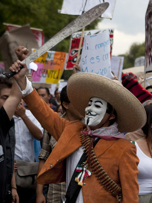
The protester shown here objects to a possible return to rule by the PRI -- the Institutional Revolutionary Party, and oddly-named coalition that ruled Mexico longer than any other political party in modern history -- over seventy years -- before its power was eroded from both the left (PRD) and the right (PAN).

Tuesday, June 20, 2023

Google MyMaps

Version of June 23, 2023. This page is very much a work in progress.

For as long as Google has been Google, I have been using Google, because we early web users were happy to have it and we enjoyed playing with the DMOZ pages that initially guided its searches.

And for as long as users have been able to make Google Maps, I have been making Google Maps, embedding them on many web sites and blog posts. My most ambitious Google Map, in fact, has been a collaboration among seminar students and myself over close to a decade.  That one is, naturally, coffee-related.

Image shamelessly lifted from 2023 Google MyMaps,
a 45-minute tutorial from GeoDelta Labs.

When it first emerged, my experience with actual GIS software was fairly recent.  I had been the first person to teach it at the University of Arizona and had been taking some online courses to remain current. Over time, though, my GIS skills have faded, so that I have relied on colleagues and students when spatial analytic heavy lifting is needed. Google Maps works only with point data, after all, and has no analytic capacity beyond measuring the distances between them.

For many instructional purposes and planning purposes, however, it is just what the doctor ordered (in this case, a doctor of geography). And order it I have -- for tracking personal life lists, planning family trips, illustrating stories or song lyrics, and much more. 

A beautiful thing about these maps is that they are easy to update, and old links will take users to the most recent information.

(NOTE: My high praise does not mean that I believe Google is always correct. On two occasions, I have provided the company with corrections where map errors might cause problems for users not familiar with the locations involved.)

I recently decided that I would like to be able to send readers to the "My Maps" screen from which I can access all of my maps, but apparently this is not possible, and Google has not yet responded to my suggestion to make it easy. 

So I'm providing a lightly annotated, slightly kludgy version of my directory, in no particular order. The thumbnails and descriptions below are augmented by more complete descriptions on the map pages themselves. And MANY of the locations on the maps include links to site-specific information I have created. 

Please enjoy these and let me know if you create any maps of your own.


A "busman's holiday" refers to a vacation taken by a person to a place involved in their own professional work, as with a tour-bus driver going on a bus tour. We use a similar term whenever My Favorite Librarian visits a library while we are traveling. Bus Person's Libraries is a partial life list -- mainly for Pamela -- that includes at least one memorable library I have visited without her.


GeoCafes is the most ambitious of my Google Maps and the one mentioned above. It is the companion toe the eponymous GeoCafes blog, to which well over 100 students have contributed since 2012. Most of the map entries point to reviews by those students. I often rely on this to find local cafes while traveling, especially in Massachusetts.


Many people say that they never visit local sites of interest unless company comes from far away. Geographers are not those people -- as a group, we love exploration, locally and globally. The GeoDates Map grew from a conversation with a colleague and is a detailed guide to places our own Bridgewater geography students can visit, most of them at low cost and with less than two hours driving from campus.  It accompanies the GeoDates blog post that provides many more details.


The National Park Life List map is a life list that I started during the pandemic, as I reflected on some of the places I've been lucky enough to visit -- National Parks of the United States and a few other countries. Along with National Parks, I include other kinds of sites managed by the National Park Service. As a practical matter, the distinctions are mostly minor. The only important distinction is that National Monuments are named by Executive Order rather than Acts of Congress and as a result may be removed from NPS oversight by subsequent presidents. Fortunately, we have only had one president petty enough to do such a thing, and he is out of office. 


(October 25, 2023 update) An earlier version of this blog post showed a combined national parks and museum list, because for some reason, I decided to make museums a separate layer on the same map. I recently decided to give each category its own map, but it is still possible to do a bit of very low-key spatial analysis -- when viewed at the continental scale, it seems clear that I have found many more museums to visit in the East and many more NPS sites in the West.

Another October 25 update is that a student asked about museums in western Massachusetts yesterday and I realized that I was missing THREE in western Massachusetts and one in Connecticut, including the Eric Carle, which I had been to a half-dozen times. All better now, thanks to Taylor's question!


Good friends of ours in Bridgewater moved north about a decade ago to fulfill their dream of becoming innkeepers. In visiting their lovely inn over the years, we learned that many of there summer guests were on a 40-mile trek among four inns in their area, and that Vermont Inn Walking was an inn-walking tour that had been operating in the past and had been revived by a new generation of owners at the participating inn. We used this map better to envision our May 2023 journey and also to figure out which nearby sites we might be able to visit on the way to or fro. (Note: I deleted the homes of two friends in the area, one of which we did manage to visit.)


My father was not just an elevator mechanic; in many ways he was the elevator mechanic -- the GOAT of elevator mechanics. During the State of the Union Address, he sometimes sat in the Capitol, just in case. When the president of the United States needed a new elevator, he swapped shifts with another mechanic around the clock to get it done. Twice. Nobody could make a map of every place Jim Bohanan installed, maintained, or replaced an elevator. But since my mother's passing in 2020, I spend long mornings on the phone with him each week, often talking about his former work. And when a notable site comes up, I add it to this map.


My wife Pamela and I famously met in Maryland, where she had grown up and where Rachel Carson had done much of her scientific research and writing. Because Rachel Carson died the month before Pamela was born and they share a birthday, we think of them as perhaps sharing a mystical connection. Carson is mentioned in many contexts on Pamela's library-books blog and on this environmental blog, and comes up frequently in our teaching and outreach. 

All of which is to say that Rachel Carson is an important figure in the Hayes-Boh household, but until very recently we had never visited any of the landmarks associated with her life and work. Her residence in Maryland was in the vague suburbs north of D.C. and her work was in an oddly rural zone intertwined with the sprawl of Baltimore, Washington, and a Naval Air Station. So when the whole family found ourselves staying at an Airbnb in the area in 2021, I decided to find those Maryland landmarks, and ultimately to map all of the Rachel Carson sites that I could find.


I first crossed the U.S.-Mexico border from San Ysidro to Tijuana as part of a very brief visit to Ensenada in 1985, a year after a massacre at a McDonald's on the U.S. side. The place had been very much in the news that year, but I did not realize how very close to Mexico it was until my friend Mike and I drove to the empty lot that had been the restaurant.

I next crossed the border at the very opposite end in 1989, when I had the opportunity to inspect a dry cleaner in the town of Mercedes, Texas. Several of us were qualified to do the work, but I asked for the assignment because I was beginning to become a bit specialized in the operations of dry cleaners and more importantly Pamela and I had spent the previous summer in central Mexico, and I was interested in returning to the country. As I often did on such inspection trips, I got a room and a car for several days, and did as much exploring as I could after hours, and I managed to find a place to park in Brownsville and walk across the border to Matamoros. 

Little did I realize that the next year I would begin seven years of living in the border zone, during which I would make more than half of the crossings between these east and west extremes. It is a bit difficult to count, since some crossings have opened and others have closed over the past few decades. 

Author Tom Miller (for whom Pamela would eventually work as a research assistant) had made a point of making absolutely every crossing as he prepared his 1981 masterpiece On the Border: Portraits of America's Southwest Frontier. My experience will never be as complete as Miller's had been, nor would I enjoy trying to fill the remaining gaps in my own map. Both Miller and I (and Pamela -- who has crossed everywhere I have, except San Ysidro) crossed, the United States was still a country that greatly valued freedom of movement. Crossings were always subject to inspection, of course, but the militarization of the border did not begin until the 1990s, and of course it was amplified after September 11, 2001. 

Thanks to those readers who have stayed with this map description for so long. I only spent about a tenth of my life (so far) in the borderlands, but the experience was profound. Since moving more than 2,000 miles from the nearest point along the border, I have made it my mission to inform other folks in the U.S. about its myths and realities.  A search of my phrase human sieve on this blog points to more than a dozen entries about the complexities of that line. 

For now I will add that a writer were were privileged to know during our time in Arizona helped me to think more positively about the region, despite the efforts of politicians, criminals, and pundits to make it something different. In Border People, Oscar Martínez describes a zone that is neither exactly Mexico nor exactly the United States. I read the book when I knew Oscar and lived in the region; I think it might read today more as history than anthropology, as many of the comings and goings he describes would now be difficult if possible at all.


Among the many, many disappointments in 2020 was the postponement and eventual cancellation of our nieces fancy wedding in Scotland. I have not been in western Europe at all (outside of Heathrow Airport) and Pamela had not been since the 1980s. So we had extensive plans to explore while "in the neighborhood" for a wedding that would have taken place where my forebears lived in the seventeenth century. I am holding on to the wedding travel map against the day we make this a retirement outing.


Since 2008, I have been part of a geography outreach project we call Project EarthView, in which we take a giant inflatable globe -- a sort of portable geography classroom -- to schools. The program later expanded to include giant floor maps, and has given us the chance to talk about geography with well over 100,000 students, their parents, teachers, local officials, and reporters. A few years into the project, I decided we should map the places we have been. I have done my best -- with the assistance of colleagues who have been part of the program -- to include every place we have taken the globe on the EarthView Experience map. 

Fun fact about scale: to avoid any ambiguity, wherever possible, I have placed the Google location marker precisely on the building -- and the part of the building -- where we set up the globe. At a small scale, a viewer can see which towns we have visited. Zoom in to a larger scale, and one might see that we were in the eastern half of a big gymnasium.


This map is a bit silly -- Across Two Fridays is a subset of the EarthView Experience map shown above, because I wanted to document a particularly busy week in our life of geography outreach. Between two Fridays our team visited six schools -- elementary, middle, and high schools -- none of which was near any of the others.  We scrambled a bit extra that week, squeezing in a visit to King Philip Middle School in Plainville to surprise Sathwik Karnik, who had won the 25th National Geography Bee with Alex Trabek just a few weeks before. 


In a sense, the Marshall School Families map flips the EarthView script. We use our big globe to help bring conversations about the wider world to a local school. The EarthView Experience map shows all of the places we have done so. Marshall School is a wonderful neighborhood school in Quincy, Massachusetts. During a visit there, we gradually realized that much of the world was represented in that school -- so much so that this map represents just the fourth graders we met on that one day. Each marker points to the capital of a country mentioned as their family's home country by one or more students.


I created the Brockton Walking Tour, October 2016 map for a one-time walking tour of the nearby city of Brockton that I led for an interdisciplinary group of BSU Honors students. Several years before, I had taught a First-Year Seminar about the city, but it had a minimal field component. I later revived the course as an Honors FYS with substantial field experiences, as described in Brian Benson's 2019 City Champions article. This map is greatly in need of some development. I points to locations without any elaboration; I hope to involve students in my Fall 2023 class in connecting the map to some more information, including some Sidewalk Survey recordings I have already put on YouTube and some bibliographic connections to local experts who helped me plan that original tour.


I created Geography of Coffee - BSU in Costa Rica to document the places we visited on my most recent travel course, when my friends at Matagalpa Tours -- who had co-taught most of my Nicaragua travel courses -- arranged a wonderful program in Costa Rica. When we made this trip in January 2020, I had no idea that it was to be my last international travel for more than three years. 


Geography of Coffee in Fogo is a planning map for my next travel course, in which my colleague Angelo Barbosa and I will explore the small but fascinating coffee industry in Cabo Verde (Cape Verde). Many of the world's best coffees grow on the slopes of dormant volcanoes. To my knowledge, Fogo (Fire) is the only place in the world where coffee is grown in the caldera of an active volcano. Whenever it erupts, people leave and then return, perhaps to a different part of the crater. If you are reading this during 2023, please click the link above and consider joining us!


The Peru - Travel Course map is for a class that has not yet been taught.

I spend a lot of time in schools, and many of the teachers I work with have told me they would love to take my coffee travel course, but they cannot go on my January courses, which coincide with the Central American coffee harvest. So I checked the world harvest calendar, saw that Peru would be good for a summer class, and then worked with my colleague Dr. Rob Hellström to develop a course that would involve coffee and his ongoing climate research projects in Peru. 

We did get a few of our BSU students to sign up, but no teachers. That was 2017; we would love to try again some time. Let me know if you are interested enough to put down a deposit on such a course.


My Peru map includes a layer based on the as-yet-imaginary travel course mentioned above and another layer based a birthday trip to Machu Picchu with my favorite librarian in 2014. After three decades of travel, study, and work in Latin America, this was the first experience in the Andes for both of us. We made a point of finding lodging a bit out of the way from most of the tourism. We stayed in and traveled among many locations in which Spanish was not even the dominant language. It was delightful!


The fact that neither of these extensive trips would have anything in common except for the Lima airport reminds us that Peru is rather a large country, as shown above on an image I created on TheTrueSize:


As soon as a new dean for continuing education (at BSU this means anything not taught 8-4 in a regular semester) announced that he was allowing for summer courses that would be taught in just 5 eight-hour days, the idea of Coffee Week was born. At first, I thought I would do some lectures and show some movies all week, and then visit a roaster and café or two. By the time summer had arrived, this had become a full-on coffee crawl. As Coffee Week 2016 shows, we went to so many cafés that the students were refusing free coffee by the end of the afternoons. We learned a lot and the students took some terrific photographs! (Most of these businesses are still in business, but sadly some cafés on this map no longer exist, so check ahead before you travel to any of them.)

As the name implies, Coffee Week BSU 2017 is a map of the places we went during the course's second offering -- it was just as enjoyable. Although we tried to offer it a few more times, we were never able to gain enough enrollment for the course to run again. In-person summer classes were very difficult to fill even before Covid-19. I do not think we will be able try this concept again. 

BSU Nicaragua is a simple map with a brief title, but there is more experience behind this map than any other I have made. Anything I do related to coffee began with my decision to take students to Nicaragua in 2006 -- just one time, I thought. 

A search for Nicaragua on this blog will bring scores of articles, most of which relate to some place I have visited on this map, and a dozen of the albums in my Flickr account are from the trips represented here. Between 2006 and 2018, I took 12 student groups (with occasional friends or family included) on travel courses -- well over 100 people, some of them 2-3 times. None of them went to every site on this map, but all of them went to most. And of course, each site on this map is full of memories for me. 


And now back to some teaching that is not coffee-related. The GEOG 332 shows only four points, all of which I have visited and two of which are field-trip destinations in my course GEOG 332: Land Protection. As I prepared this blog post, I decided that annotations for those points would be a good addition. Feel free to click through to see a bit of what this course is about. I am fortunate to have taught it in alternate fall semesters for more than 20 years. I am looking forward to the next time, starting in September 2023.


The Global Guardians map is another example of a map connected to a specific, non-coffee course. In this case, the map was created with the direct assistance of students in a course. GEOG 130: Environmental Geography is a survey course that is central to my identity as a geographer. In the early days of Google, simply searching on the title of the course would bring up my web page as the very first result (a parlor trick I cannot do any more). I have taught the class more than 100 times in many different formats. For the past decade or so, my main textbook has been The View from Lazy Point by the amazing Carl Safina.

Of all the approaches I have taken to this course, I have found to be the use of his book to be the most successful. But a few years ago, I realized that the combination of his text and my teaching did not allow sufficient space for non-male voices in what should be a comprehensive discussion. As I describe in my 2020 Guardian Women blog post, I found a rich array of female environmental leaders to introduce to my students. My favorite librarian helped me to develop a series of assignments to deepen those introductions and one result is a map that my students made to show where some of those women lived and worked.


The Bridgewaters Project map points to every place I know of that shares its name with the town where we have lived and worked since 1997. Soon after moving to Bridgewater, Massachusetts we learned that it is named for Bridgwater (sic), England and also shares a name with Bridgewater, Nova Scotia. Gradually, we learned that quite a few states have a town (or several) with the same name, and that many smaller places (like shopping malls) also share it. Thus was a quest begun, and in 2009 we began the Bridgewaters Project blog, documenting Bridgewaters we had already been and giving us an excuse to visit others. Our local newspaper eventually learned what we were up to and sent a reporter to write about it and take a wide-angle photo of us in our hallway full of Bridgewater prints and maps.


As mentioned above, the Bridgewater in Nova Scotia is of particular importance in our Bridgewaters Project, so our 2018 visit there was a big deal for us. We spent a couple of nights in a perfectly lovely B & B in Bridgewater itself. We also visited some truly amazing places on our way to and from Bridgewater and quite a few others in the vicinity. We would love to go back, and not just because of the incredibly warm welcome we received in the local historical society. Of course, our Bridgewater, Nova Scotia blogpost has a lot of fun details, and the Nova Scotia 2018 map was essential to the journey. 


Mermaids might be the silliest use I have made of Google Maps so far, only because there are several levels of family-blogging absurdity involved. The map is embedded in a post on our Bridgewaters Project blog, which in turn is referenced in the Mermaids entry on our All Noni blog. For those readers who are new here, the former is about our determination to write about all places named Bridgewater and the latter is about our determination to write about every film, television show, or short work involving Our Noni, otherwise known as Winona Ryder.  
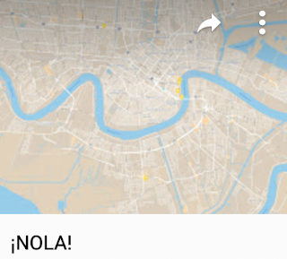


For the past several years, I have taught one-credit Honors colloquia about cities that interest me greatly but that I had not visited when I started this practice. Initially, I offered Detroit and New Orleans because they were the U.S. cities about which I had done the most reading and thinking, music listening and film watching, without having actually visited. Even a lot of cities I had visited in person had not captured my attention so much. I have since visited Detroit for just 21 learning-packed hours, but I have not made it to NOLA yet. 

I bring a lot of maps into these classes and I have students bring in even more. The simple ¡NOLA! map shows just one kind of thing: the locations of international consulates in New Orleans. It seems to have a lot of consulates for a city its size, and they are not random. Rather, they reflect the places to which New Orleans has had -- and continues to have -- the most important connections through trade, migration, and cultural exchange.

The Chan Chan map is similar to some of the others mentioned so far, in that it shows the places mentioned in a work of art, in this case a song by the same name. Not just a song, though: the song that has come to represent an important moment in Cuban music and the performers who represent that moment: Buena Vista Social Club. In this case, the map arose from my own curiosity about the song -- I could not decipher its meaning until I figured out which words were place names. I embedded the map in my 2013 Hoguín Son post. (That is the Spanish word "son" for "sound" not the English word for a male heir.)


I made the Garifuna map for students in my New Orleans class. It has just three points, but they are important for understanding the geography of Garifuna language and culture in the Caribbean region. 


I hope that people are still aware of the story of Malala Yousef, a Pakistani woman who was nearly killed about a decade ago for pursuing an education and whose courage captured the imagination of millions. My first blog post about her was my 2014 Crisp and Self-Assured, which had to do with pundits like Rush Limbaugh supporting her attackers. When I wrote Riveting Malala a bit later that year, I created the map Malala Locations from the Memoir, because her book mentions many places that are not at all familiar to most of her readers. As with any of my maps, the idea is not simply to notice where the points are, but rather to use these maps as a point of departure for further exploration. Once we know where various events in her life took place, we can use these and other maps to learn more about those places. Are they hot, dry, steep, flat, forested, urban, rural -- what kinds of places are they?


The Malbeclipse 2019 map describes personal travel with a complicated story that began with a jury-duty summons two years prior. Pamela had received a summons for federal jury duty that would have disrupted the long-planned (and very geographic) celebration of our 30th wedding anniversary. The feds let her off the hook, but stressed that there would be NO MERCY during the make-up week a few months later. So when friends invited us to return to their home in Kearney, Nebraska for a total eclipse of the sun, we declined so that Pam could call the court every night. 

Salta is on the map for next time!
Image: Descubre Argentina 
Of course, she was never seated on that jury, but our hopes were dashed. This geographer immediately set about searching upcoming eclipses and noticed that a 2019 event would be very close to Mendoza, Argentina -- an Andean town that is the source of most of the red wine we drink in our home -- Mendoza Malbec. As we were making plans, I was fortunate to meet someone from Chile who convinced me that the Elquí Valley of Chile would be a better viewing area. It is home to one of the world's most important clusters of astronomy researchers because of the incredibly clear skies at the edge of the Atacama Desert. So the question was: Argentina or Chile? The answer was: yes, both. We went to Chile for the eclipse and then flew to Argentina for the wine. We did not lack for wine on the Chilean side of the mountains of course, but we had our hearts set on Mendoza!  The Malbeclipse 2019 map includes some details about our lodging and transportation and also the half dozen or so vineyards we visited. 

Bonus: I just added an icon to this map for our next visit. We need to return to both sides. I would love to spend a month or so in Elquí and we also need to get to the Gabriela Marquez museum that was closed the day we tried to visit. 
On the Argentine side, we visited quite a few vineyards, including one in the distinct Uco Valley district to the south of Mendoza proper, but we left about 250 vineyards unvisited. We were also there in southern winter, and I wonder how crowded the entire area must be in peak season. The icon I have added is not for any particular vineyard in Mendoza -- though we do have some favorites. Rather, it is for another growing area -- even higher in elevation and well to the north: Salta. We have had a few exquisite wines from there. Moreover, an image I recently found on the Descubre Argentina tourism site suggests the kind of alpine village scene I had imagined but not found in Mendoza. I'm willing to give it a try!


Onyema Ogbuagu is a map that is named for a person -- a person whose name recognition is tiny (even I had forgotten why I made this map) despite the immense importance of his contribution to global well-being.  As I mentioned in my 2020 Thanks to Doctor Ogbuagu blog post, he is a Yale researcher who played a vital role in the development of a Covid-19 vaccine that saved millions of lives and allowed billions of people to return to something like normal living after the global pandemic. His biography mentioned several academic sites throughout Nigeria that were unfamiliar to me, so of course I made a map!


Those who click on my Georgia Planning map (and I hope that includes whomever is reading right now) will notice that this is, as we say, Georgia the country, not that place where we keep Atlanta. This is the former Soviet republic on the Black Sea that a certain crazy man in Moscow has made some efforts to reconquer. It is mountainous country of great political and geological complexity, considered equally Asian and European -- neither and both, in the minds of many.

We have been learning a lot about Georgia since 2017, when we hosted a Georgian geologist in our home for a couple of months while he used our university's facilities for some fascinating work trying to untangle some of that geology. We were fortunate that he returned for a brief visit a couple years later and that we have stayed in touch online. (No worries -- on our part -- that Georgian is an extremely unusual and difficult language. Our friend Luka is fluent in at least four languages, one of which is English!)

Among the interesting things we have learned is that Georgia is the FIRST place on the planet to have made wine; those who have been paying attention will know that this alone is reason enough for a Hayes-Bohanan visit. We are also interested in some outreach related to geography education and simply visiting Luka and other Georgian friends in their home country. So far this is a planning map with no date (Covid-19 threw us off some former plans), but definite strong intentions. (Fun fact: Tbilisi is one of three national capitals on the same latitude as our home near Boston.)


The Puerto Rico 2016 map began as a planning map but now serves as an annotated record of our visit that year, including a link to all of my photos from the journey. So far this is the only time any of the Hayes-Bohs have visited the island, which would be the 51st state already, were it not for the opposition of Kentucky Senator Mitch McConnell, our country's most effective bigot. 

Our son went to the sort of school where the parents' fundraising auction included fancy vacations, and we decided to splurge on an offer of a few days in a villa on the north coast of the island. It is not the sort of place we would normally vacation on our own -- the offer was somewhat off-season, so we had not only a huge villa but almost an entire gated community to ourselves. No complaints, though: it was beautiful, comfortable, near the ocean, and convenient for exploring much of the rest of the island. 

The map includes a description of each of the sites we were lucky enough to visit, a year before Hurricane Maria and a criminally negligent federal response destroyed many of these sites. A search of this blog for the word Boricua points to more of my pointed remarks about the treatment of my fellow citizens on the quasi-colonial island. I also recommend the documentary Yo Soy Boricua Pa'Que Tu Lo Sepas! (I'm Boricua Just So You Know) by comedienne Rosie Perez -- see IMDb entry or the entire film on YouTube. It was made in 2006 but remains the best introduction I know to the island and its connections to the mainland.

Just added in Spring 2026: HBA means Hayes-Boh Airports (it is also the real code for Hobart, Australia). 


This map locates every airport to or from which I have flown -- either as a destination or as a layover. Each one has a story! There are also just a few airports where I have not been a passenger, but for which I have a comment -- these are in orange.


I am fortunate to have lived in many parts of the United States and briefly in Mexico, Brazil, and Nicaragua. The Todas las Casas map locates all of these homes. This includes nine "Love Shack" locations with my spouse. It was Love Shack #9 to which we returned one evening, after hearing these folks perform the song in our favorite theater. 

A related map is on my Trip Advisor profile -- it shows many of the places I have visited.

MAPS TO COME!!  I have a few more to share, and I often get motivated to make new ones. There is no better form of procrastination for a geographer with a nostalgia problem.


Blog Ideas

coffee (25) GEOG381 (24) GEOG388 (23) GEOG470 (18) climate change (18) GEOG130 (16) geography (16) GEOG332 (13) GEOG431 (12) musica (11) GEOG 332 (9) GEOG 381 (9) Mexico (9) Brazil (8) GEOG286 (8) Texas (8) education (8) migration (8) GEOG298 (7) borderlands (7) GEOG199 (6) GEOG331 (6) Massachusetts (6) US-Mexico (6) deBlij04 (6) immigration (6) GEOG 130 (5) GEOG 286 (5) GEOG287 (5) climate justice (5) cultural geography (5) fair trade (5) food (5) geographic education (5) nicaragua (5) water (5) Arizona (4) GEOG 171 (4) GEOG171 (4) GEOG295 (4) Safina (4) africa (4) deBlij05 (4) land protection (4) music (4) politics (4) Bolivia (3) Boston (3) COVID-19 (3) Detroit (3) Ethiopia (3) Managua (3) Obama (3) border (3) cartography (3) drought (3) libraries (3) pesticides (3) suburban sprawl (3) trade (3) unemployment (3) Alaska (2) Amazon (2) Bridgewater (2) Canada (2) Chiapas (2) China (2) Colonialism (2) EPA (2) EarthView (2) Economy (2) Environment (2) GEOG 199 (2) GEOG 287 (2) GEOG 388 (2) Google Maps (2) Government (2) Hawaii (2) India (2) Lexington (2) Maldives (2) Mozambique (2) NOLA (2) NPR (2) National Monuments (2) National Parks (2) New Orleans (2) Religion (2) Rio Grande (2) Taunton River Wild and Scenic (2) Tex-Mex (2) The View from Lazy Point (2) United States (2) Venezuela (2) anthropocene (2) cape verde (2) censorship (2) central america (2) chocolate (2) corn (2) deBlij07 (2) deforestation (2) demographic transition (2) demography (2) education reform (2) employment (2) environmental geography (2) film (2) forest fire (2) global warming (2) islands (2) landscape ecology (2) librarians (2) maps (2) organic (2) peak oil (2) refugees (2) sense of place (2) soccer (2) sustainability (2) television (2) water rights (2) whales (2) #bbc (1) #nicaragua (1) #sosnicaragua (1) #sosnicaragua #nicaragua (1) 100 Years of Solitude (1) ACROSS Lexington (1) Accents (1) Adam at Home (1) Alice (1) Alt.Latina (1) American Hustle (1) April (1) Association of american Geographers (1) Audubon (1) Aunt Hatch's Lane (1) BBC (1) BSU (1) Baby Boomers (1) Banda Aceh (1) Bay Circuit Trial (1) Bechtel (1) Beleza Tropical (1) Belize (1) Beloit College (1) Ben Linder Cafe (1) Bet The Farm (1) Bhopal (1) Biafra (1) Bikeway (1) Bikini (1) Bill Gates (1) Bill Moyers (1) Boeing 777 (1) Brazilian (1) Brazilianization (1) Bridge (1) British Columbia (1) Brockton (1) Bus Fare (1) Bush (1) Cabo Verde (1) California (1) Cambridge (1) Cape Cod Bay (1) Carl Stafina (1) Catholic (1) Ceuta (1) Chalice (1) Chipko (1) Citgo (1) Climate risks (1) Cochabamba (1) Colombia (1) Common Core (1) Commuter (1) Computers (1) Cuba (1) Cups and Summits (1) Dallas (1) David Byrne (1) Deans Beans (1) Delaware Valley (1) Dunkin Donuts (1) Earth Day (1) Earth View (1) Easton (1) El Salvador (1) Elizabeth Warren (1) Ellicott City (1) Emilia Laime (1) English-only (1) Environmental History (1) Euphrates (1) European Union (1) Evo Morales (1) FIFA (1) FYS (1) Fades Out (1) Farms (1) First-Year Seminar (1) Food Trade (1) Frederick Kaufman (1) French press (1) Fresh Pond Mall (1) GEOG 431 (1) GEOG 441 (1) GEOG213 (1) GEOG490 (1) Gabriel García Márquez (1) Garden of Gethsemane (1) Gas wells (1) Gateway Cities (1) General Motors (1) Gini Coefficient (1) Girl in the Cafe (1) Google (1) Gordon Hempton (1) Gravina Island Bridge (1) Great Migration (1) Great Molasses Flood (1) Guy Lombardo (1) Haiti (1) Hawks (1) Heart (1) Higher Education (1) History (1) Holyhok Lewisville (1) Homogenous (1) Honors (1) How Food Stopped Being Food (1) Hugo Chavez (1) IMF (1) Iditarod (1) Imperial Valley (1) Income Inequality (1) Indonesia (1) Iraq (1) Irish (1) Japan (1) Junot Diaz (1) Kenya (1) Ketchikan (1) Key West (1) Kindergarden Students (1) King Corn (1) Kiribati (1) Latin America (1) Limbaugh (1) Literature (1) Living On Earth (1) Louisiana (1) Love Canal (1) Luddite (1) M*A*S*H (1) MCAS (1) MacArthur Genius (1) Maersk (1) Malawi (1) Malaysia (1) Malaysian Air Flight 370 (1) Mali (1) Manu Chao (1) Map (1) Marblehead (1) Mary Robinson Foundation (1) Maryland (1) Massachusetts Bay Colony (1) Math (1) Maxguide (1) May (1) Maya (1) Mayan (1) Mayan Gold (1) Mbala (1) McDonald's (1) Melilla (1) Mexicans (1) Michael Pollan (1) Michelle Obama (1) Micronesia (1) Military (1) Military Dictatorship (1) Minuteman Trail (1) Mongolia (1) Monsanto (1) Montana (1) Morocco (1) Mount Auburn Cemetery (1) Muslim (1) NPS (1) Nantucket (1) National Education Regime (1) Native American (1) Native Americans (1) New Bedford (1) New Hampshire (1) New York City (1) New York Times (1) Nigeria (1) No Child Left Behind Act (1) Norquist (1) North Africa (1) Nuts (1) Oakland (1) Oaxaca (1) Occupeligo (1) Occypy (1) Oklahoma (1) Oklahoma City (1) Oppression (1) PARCC (1) Pakistan (1) Pascal's Wager (1) Peanut (1) Pearson Regime (1) Philadelphia (1) Philippines (1) Pink Unicorns (1) Poland (1) Portuguese (1) Protest (1) Public Education (1) Puebla (1) Puritans (1) Quest University (1) Rachel Carson (1) Reading (1) Republican (1) Retro Report (1) Robert Reich (1) Rock Legend (1) Ronald Reagan (1) Rondonia (1) Rosa Parks (1) SEXCoffee (1) Safety (1) Samoza (1) Sandino (1) Sara Vowell (1) Save the Children (1) Scotch (1) Scotland (1) Seinfeld (1) Senegal (1) Sergio Mendes (1) Severin (1) Sharrod (1) Silent Spring (1) Sinatra (1) Slope (1) Smokey the Bear (1) Somalia (1) Sombra (1) Sonora (1) Sonoran desert (1) Sonoran hot dog (1) South America (1) Spain (1) Stairway to Heaven (1) Storm (1) Suare Inch of Silence (1) Sumatra (1) Swamp (1) Tacloban (1) Tanzania (1) The Amazon (1) The Amazon Trail (1) Tigris (1) Tucson (1) Tufts (1) U.S Federal Reserve (1) U.S Government (1) U.S. economy (1) USDA (1) USLE Formula (1) Uganda (1) Unfamiliar Fishes (1) Union Carbide (1) Vacation (1) Vexillology (1) Vietnam (1) ViralNova (1) WNYC Data News (1) Wall Street (1) Walsenburg (1) Walt Disney (1) Walt and El Grupo (1) Ward's Berry Farm (1) West (1) Whaling (1) Wilson (1) Winter Storm Saturn (1) Wisconsin (1) World Bank (1) Xingu (1) YouTube (1) Zombies (1) agriculture (1) antitrust (1) aspen (1) austerity (1) aviation (1) banned books (1) bark beetle (1) bean (1) beavers (1) bicycle (1) bicycling (1) bike sharing (1) binary (1) biodiversity (1) bioneers (1) books (1) boston globe (1) cacao (1) cafe (1) campaign (1) campus (1) cantonville (1) capitals (1) carbon dioxide (1) carbon offsets (1) carioca (1) cash (1) cashews (1) census (1) chemex (1) chemistry (1) chronology (1) churrasco (1) civil rights (1) coffee grounds (1) coffee hell (1) coffee prices (1) coffee quality (1) college (1) compost (1) computerized test (1) congress (1) conservation commission (1) corporations (1) countries (1) cubicle (1) dams (1) deBlij06 (1) deBlij08 (1) death (1) deficit (1) development (1) dictatorship (1) distracted learning (1) distraction (1) drug war (1) dtm (1) earth (1) economic diversification (1) economic geography (1) election (1) embargo (1) energy (1) enhanced greenhouse effect (1) environmentalist (1) ethnomusicology (1) exremism (1) failed states (1) farming (1) financial crisis (1) football (1) forestry (1) forro (1) fracking (1) free market (1) free trade (1) fuel economy (1) garden (1) genocide (1) geography education (1) geography games (1) geography of chocolate (1) geography of food (1) geologic time (1) geotechnology (1) gerrymandering (1) global pizza (1) globe (1) goodall (1) green chemistry (1) ground water (1) guacamole (1) guatemala (1) habitat (1) high-frutcose (1) home values (1) hospitality (1) hourglass (1) housing (1) hydrology (1) illegal aliens (1) income (1) indigenous (1) interfaith (1) journalism (1) kitchen garden (1) labor (1) language (1) libertarianism (1) library (1) linguistics (1) little rock (1) llorona; musica (1) macc (1) maccweb (1) magic realism (1) maple syrup (1) mapping (1) masa no mas (1) massland (1) medical (1) mental maps (1) mi nina (1) microlots (1) microstates (1) mining (1) mltc (1) monopoly (1) municipal government (1) nautical (1) neoclassical economics (1) new england (1) newseum (1) newspapers (1) noise pollution (1) pandas (1) petroleum (1) piracy (1) pirates (1) poison ivy (1) police (1) political geography (1) pollution (1) provincial government (1) proxy variables (1) public diplomacy (1) quesadilla (1) rabbi (1) racism (1) real food cafe (1) regulations (1) remittances (1) resilience (1) resistance (1) respect (1) rigoberta menchu (1) rios montt (1) romance (1) roya (1) runways (1) russia (1) satellites (1) science (1) sea level (1) selva negra (1) sertao (1) sertão (1) sex (1) sex and coffee (1) simple (1) sin (1) smokey (1) solar (1) solar roasting (1) south africa (1) sovereignty (1) species loss (1) sporcle (1) sports (1) state government (1) taxes (1) tea party (1) teaching (1) textile (1) texting (1) tortilla (1) training (1) transect; Mercator (1) travel (1) triple-deckers (1) tsunami (1) urban geography (1) utopia (1) vermont (1) vice (1) video (1) wall (1) water resources (1) water vapor (1) whiskey (1) whisky (1) widget (1) wifi (1) wild fire (1) wildfire (1) wildlife corridor (1) wto (1)